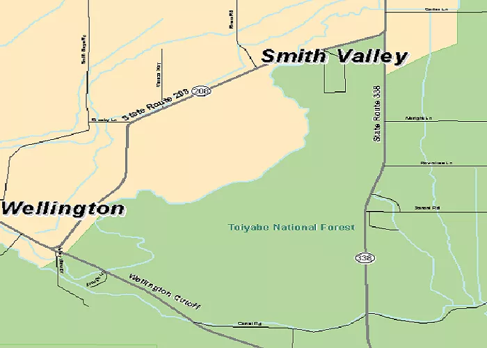
Smith Valley is a picturesque region located in western Lyon County, Nevada, known for its rich history and scenic landscapes. Understanding its geographical layout is essential for visitors, residents, and enthusiasts of Nevada’s natural beauty.
Smith Valley, nestled in the western part of Lyon County, offers a unique blend of historical significance and natural allure. The valley is bordered by mountain ranges and is traversed by the West Walker River, contributing to its fertile lands. A detailed map of Smith Valley provides valuable insights into its terrain, infrastructure, and neighboring areas.
Geography of Smith Valley
Smith Valley sits between two mountain ranges: the Sweetwater Mountains to the west and the Pine Nut Mountains to the east. The valley is part of the Mason Valley region, which includes other nearby communities like Yerington and Wellington.
The Walker River flows through Smith Valley, providing water for farming and wildlife. The valley has fertile soil, making it an important agricultural area in Nevada.
Key Geographic Features:
- Sweetwater Mountains – A scenic range with hiking trails and wildlife.
- Pine Nut Mountains – Known for pine nuts and outdoor recreation.
- Walker River – A vital water source for the valley.
- Desert Landscapes – Parts of the valley have dry, desert-like conditions.
Map Resources
For a comprehensive understanding of Smith Valley’s layout, the following map resources are available:
- Smith Valley 100K Quad Map: This topographic map offers detailed information about the valley’s terrain and features.
- Smith Valley Nevada/California Quad Map: Provided by the Carson Water Subconservancy District, this map highlights the geographical features of the region.
- Aerial Photography Map: For a bird’s-eye view of Smith Valley, aerial photographs from 2019 are available, showcasing the landscape and infrastructure.
Neighboring Communities
Smith Valley encompasses several communities, each contributing to the area’s unique character:
- Smith: Located within the valley, Smith is a small community offering local amenities and serving as a hub for agricultural activities.
- Wellington: Situated at the southern end of the valley, Wellington provides access to various recreational opportunities and serves as a gateway to California via State Route 182.
- Yerington: Approximately 23 miles northeast of Smith Valley, Yerington is the county seat of Lyon County, offering additional services and cultural attractions.
Transportation Routes
Key transportation routes facilitate access to and within Smith Valley:
- Nevada State Route 208: This highway runs through the valley, connecting Smith Valley to Yerington and providing access to U.S. Route 395 north of Topaz Lake.
- Nevada State Route 338: Leading south from Smith Valley, this route reaches the California border, where it continues as State Route 182, eventually reaching Bridgeport, California.
Smith Valley Nevada Map: Towns and Communities
Smith Valley is a small but close-knit community. The main town in the area is Smith, which serves as the center of the valley. Other nearby communities include:
- Wellington – A small town to the north with historic sites.
- Topaz Lake – A popular spot for fishing and boating.
- Yerington – The largest nearby city, offering more services.
The map of Smith Valley Nevada shows that most homes and businesses are spread out. The area has a rural feel, with large ranches and farms.
Roads and Highways in Smith Valley
Traveling in Smith Valley is easy thanks to well-maintained roads. The main routes include:
- Highway 208 – Runs through the heart of Smith Valley, connecting to Wellington and Yerington.
- Highway 338 – Leads to the California border and the town of Bridgeport.
- Smith Valley Road – A local road that passes through farms and neighborhoods.
The map of Smith Valley Nevada shows that most roads are straight and easy to navigate. However, some rural roads may be unpaved, so drivers should be cautious.
Landmarks and Points of Interest
Smith Valley has several interesting places to visit. Here are some key landmarks:
1. Smith Valley Museum
This small museum showcases the history of the valley. Visitors can see old farming tools, photos, and Native American artifacts.
2. Topaz Lake
A beautiful lake on the Nevada-California border. People come here for fishing, camping, and water sports.
3. Sweetwater Summit
A high point in the Sweetwater Mountains with great views of the valley. Hikers enjoy trails in this area.
4. Local Farms and Ranches
Smith Valley is known for its agriculture. Many farms sell fresh produce, eggs, and beef.
Smith Valley Nevada Map: Outdoor Activities
The valley is perfect for nature lovers. Popular activities include:
- Hiking – Trails in the Sweetwater and Pine Nut Mountains.
- Fishing – Topaz Lake and the Walker River are great spots.
- Hunting – The area has deer, quail, and other game.
- Horseback Riding – Many ranches offer riding trails.
Climate and Weather in Smith Valley
Smith Valley has a semi-arid climate. Summers are hot and dry, while winters are cool with some snow. The best time to visit is spring and fall when temperatures are mild.
Average Temperatures:
- Summer (June-August): 85°F – 95°F (Hot, dry)
- Winter (December-February): 30°F – 50°F (Cool, occasional snow)
Conclusion
A detailed map of Smith Valley, Nevada, reveals a region rich in natural beauty and historical significance. From its fertile lands nourished by the West Walker River to its surrounding mountain ranges, the valley offers a unique perspective on Nevada’s diverse landscapes. Whether you’re planning a visit, conducting research, or simply exploring, understanding the geography of Smith Valley enhances appreciation for this distinctive area.

