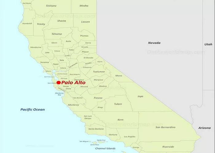
Palo Alto is a city located in the heart of Silicon Valley, California. Known for its proximity to major tech companies and prestigious educational institutions, understanding its location can be beneficial for travelers, students, and professionals alike.
Palo Alto serves as a central hub in the San Francisco Bay Area, offering a blend of urban amenities and suburban tranquility. Its strategic position makes it a focal point for technology, education, and culture.
Palo Alto’s Exact Location on a Map
Geographic Coordinates
- Latitude: 37.4419° N
- Longitude: 122.1430° W
Where Is Palo Alto in California?
Palo Alto is located:
- 34 miles south of San Francisco
- 12 miles northwest of San Jose
- On the San Francisco Peninsula, between the Santa Cruz Mountains and San Francisco Bay
How to Find Palo Alto on a Map
1. Look for the San Francisco Bay Area.
2. Find Stanford University (a major landmark).
3. Trace Highway 101 or Interstate 280—Palo Alto sits between these two major freeways.
Neighboring Cities and Landmarks
Palo Alto shares borders with several notable cities and landmarks:
- East Palo Alto: Located to the east, this neighboring city is separated from Palo Alto by the San Francisquito Creek.
- Menlo Park: Situated to the west, Menlo Park is known for its residential communities and commercial areas.
- Mountain View: To the south, Mountain View houses the headquarters of major tech companies, including Google.
- Stanford University: Bordering Palo Alto to the north, Stanford University is a world-renowned institution contributing significantly to the region’s cultural and educational prominence.
Major Highways & Transportation Routes
Key Freeways Near Palo Alto
- Highway 101 – Runs north-south, connecting San Francisco to San Jose.
- Interstate 280 (I-280) – A scenic route along the foothills of the Santa Cruz Mountains.
- El Camino Real – Historic road running through downtown Palo Alto.
Public Transit Options
- Caltrain – Commuter rail linking Palo Alto to San Francisco and San Jose.
- VTA Light Rail – Connects to South Bay areas like San Jose.
- SamTrans Buses – Serve the Peninsula region.
Cultural and Historical Significance
The name “Palo Alto” translates to “tall stick” in Spanish, derived from a coastal redwood tree known as “El Palo Alto,” which stands as a historical landmark near the San Francisquito Creek.
Why Palo Alto’s Location Matters
Center of Silicon Valley
- Close to Google (Mountain View), Meta (Menlo Park), and Apple (Cupertino).
- Stanford University drives innovation and startups.
Proximity to Major Cities
- 30-45 minutes to San Francisco (without traffic).
- 15 minutes to San Jose International Airport (SJC).
Natural Beauty
- Near the Baylands Nature Preserve (wetlands).
- Short drive to Pacific Coast beaches (Half Moon Bay, Santa Cruz).
Conclusion
Palo Alto’s strategic location within the San Francisco Bay Area positions it as a pivotal center for technology, education, and culture. Its proximity to major cities and institutions, combined with its own unique history and landmarks, make it a noteworthy point on any map of California.

