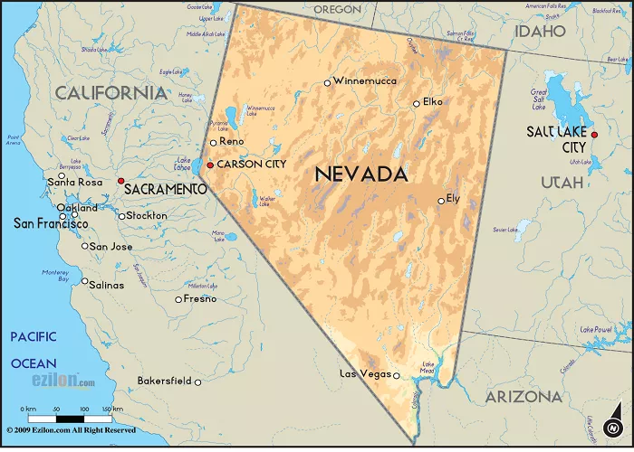
Central Nevada, often referred to as the state’s “Heartland,” is a region characterized by vast open spaces, rugged mountain ranges, and historical significance. Understanding its geography through detailed maps enhances one’s appreciation of its unique features and the role it plays in Nevada’s overall landscape.
Geographical Overview
1. Location and Boundaries
Central Nevada is generally considered to encompass the area between the Sierra Nevada Mountains to the west and the Great Basin to the east. It stretches from the northern border near the Black Rock Desert down to the southern reaches near the Pahranagat Valley. This central expanse includes parts of several counties, notably:
- Churchill County: Home to the city of Fallon, known for its agricultural contributions.
- Lander County: Contains the historic town of Battle Mountain.
- Nye County: Encompasses a significant portion of the region, including the communities of Tonopah and Pahrump.
- Eureka County: Known for the city of Eureka, which boasts well-preserved historic architecture.
- White Pine County: Includes the city of Ely, a former railroad hub.
2. Major Highways and Transportation Routes
Central Nevada’s vastness is traversed by several key highways that facilitate travel and commerce:
- U.S. Route 50 (The Loneliest Road in America): Running east-west, this highway connects towns like Ely, Eureka, and Fallon. Its desolate stretches earned it the nickname “The Loneliest Road.”
- Interstate 80: Passing through the northern part of the region, I-80 links cities such as Elko and Wells, providing a vital east-west corridor across the state.
- U.S. Route 93: This north-south highway connects Ely to Las Vegas, passing through towns like Caliente and Pioche.
- Nevada State Route 375 (Extraterrestrial Highway): Located near the western edge of the region, this highway leads to the mysterious Area 51.
3. Topographical Features
The terrain of Central Nevada is diverse, featuring:
- Mountain Ranges: Including the Toiyabe, Toquima, and Egan Ranges, these mountains offer recreational opportunities and scenic vistas.
- Desert Basins: Such as the Pahranagat Valley, characterized by expansive desert landscapes.
- Lakes and Reservoirs: Like Walker Lake and Rye Patch Reservoir, providing recreational activities and supporting local ecosystems.
Detailed Map of Central Nevada
For a comprehensive visual representation, refer to the detailed map provided by the Nevada Department of Transportation, which highlights major highways, cities, and geographical features.
Historical Context
1. Early Exploration and Settlement
Central Nevada’s history dates back to Native American habitation, with tribes such as the Shoshone, Paiute, and Goshute calling the region home. European exploration began in the early 19th century, with figures like John C. Fremont mapping the area during his expeditions. The discovery of silver and other minerals in the mid-1800s led to mining booms and the establishment of towns that still dot the landscape today.
2. The Role of the Railroad
The completion of the Central Pacific Railroad in the late 19th century brought significant changes to Central Nevada, facilitating commerce and communication. Towns like Ely and Battle Mountain grew as railroad hubs, serving as vital links between the East and West coasts.
Cultural and Recreational Significance
1. Outdoor Activities
Central Nevada offers a plethora of outdoor activities, including:
- Hiking and Camping: In areas like the Toiyabe National Forest and Great Basin National Park.
- Fishing and Boating: At lakes such as Walker Lake and Pyramid Lake.
- Stargazing: The region’s low light pollution makes it ideal for observing the night sky.
2. Cultural Events
Communities in Central Nevada host various cultural events, such as:
- The Ely Renaissance Village Festival: Celebrating local arts, crafts, and history.
- The Battle Mountain Basque Festival: Honoring the Basque heritage of many residents.
Economic Activities
The economy of Central Nevada is primarily driven by:
- Mining: Extraction of minerals like gold, silver, and copper.
- Agriculture: Ranching and farming, particularly in valleys with access to water sources.
- Tourism: Drawing visitors interested in outdoor recreation, history, and cultural experiences.
Conservation and Environmental Considerations
Central Nevada is home to vast public lands managed by agencies such as the Bureau of Land Management (BLM) and the U.S. Forest Service. These lands are crucial for preserving the region’s natural beauty and biodiversity. Ongoing conservation efforts aim to balance recreational use with environmental protection.
Conclusion
Central Nevada’s unique blend of natural beauty, historical depth, and cultural richness makes it a region worth exploring. Detailed maps of Central Nevada serve as invaluable tools for travelers, historians, and geographers alike, offering insights into the area’s complex geography and the interplay of human and natural forces that have shaped it over time.
For further exploration, consider visiting the Nevada Department of Transportation’s map resources, which provide detailed state and regional maps, including those of Central Nevada.

