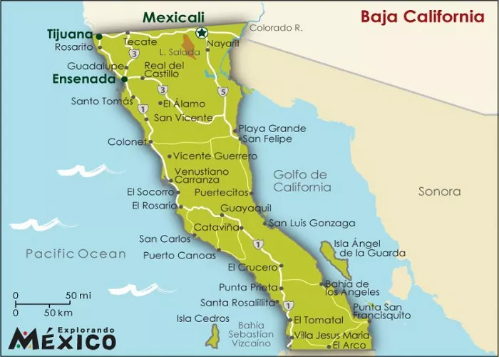
Baja California, a peninsula extending over 1,200 kilometers from the U.S.-Mexico border to the southern tip at Cabo San Lucas, is a region rich in natural beauty, cultural heritage, and adventure opportunities. Whether you’re an off-road enthusiast, a beach lover, or a cultural explorer, having a reliable and detailed map is essential for navigating this diverse landscape. This article explores some of the best maps available for Baja California, providing insights into their features, usability, and suitability for various types of travelers.
Importance of a Good Map
Navigating Baja California requires more than just a basic understanding of its geography. The region’s rugged terrains, remote areas, and limited signage in certain parts make it crucial to have a detailed and accurate map. A good map not only aids in route planning but also enhances safety by providing information on terrain types, road conditions, and points of interest.
Top Maps for Baja California
1. National Geographic’s Baja California Map Pack
National Geographic offers a comprehensive Map Pack Bundle that includes two Adventure maps covering the entire Baja California Peninsula. These maps are renowned for their accuracy, durability, and detailed representation of the region’s topography. They highlight various points of interest, including national parks, reserves, and recreational sites, making them ideal for travelers seeking both adventure and relaxation.
Features:
- Detailed Topography: The maps provide shaded relief and contour lines, offering a clear understanding of the terrain.
- Points of Interest: Locations of parks, reserves, beaches, and other attractions are clearly marked.
- Road Networks: Both primary and secondary roads are detailed, along with distance indicators.
User Feedback:
Users have praised these maps for their clarity and comprehensiveness. One reviewer noted that, among three maps tried, these were the best, though they mentioned a few omissions.
2. Baja California Road & Recreation Atlas by Benchmark Maps
Benchmark Maps’ Baja California Road & Recreation Atlas is a detailed guide showcasing the diverse recreational opportunities along the peninsula. This atlas is particularly beneficial for those interested in outdoor activities, offering insights into various landscapes and terrains.
Features:
- Landscape Maps: The atlas provides detailed representations of the peninsula’s rugged terrain, incorporating land cover data and shaded relief.
- Recreation Guides: An array of attractions and recreational sites are listed, aiding in trip planning.
- Regional Maps: These offer a broader view of the region, helping travelers understand the context of specific areas.
Availability:
This atlas is available through various retailers, including REI Co-op, where it showcases the diverse recreation opportunities found along the full length of the Baja California Peninsula.
3. Baja California Almanac
The Baja California Almanac is often regarded as one of the most detailed map resources for the region. It offers comprehensive coverage of both Baja California and Baja California Sur, making it invaluable for serious explorers.
Features:
- Comprehensive Coverage: Detailed maps covering both northern and southern parts of the peninsula.
- Road and Trail Details: Includes information on major highways, secondary roads, and off-road trails.
- Topographical Information: Provides elevation data and terrain features.
User Feedback:
Users have lauded the almanac for its thoroughness. One user mentioned it as the best map of Baja among three tried, highlighting its comprehensive road details.
4. Avenza Maps’ Baja Map Pack Bundle
For tech-savvy travelers, Avenza Maps offers a digital Baja Map Pack Bundle by National Geographic. This digital option is perfect for those who prefer using their smartphones or tablets for navigation.
Features:
- Digital Accessibility: Maps can be downloaded and accessed offline, ensuring usability without internet connectivity.
- Interactive Features: Users can pinpoint their location, mark waypoints, and track their routes in real-time.
- Comprehensive Coverage: The bundle covers the entire peninsula, from Tijuana and Mexicali to Cabo San Lucas.
User Feedback:
While specific reviews for the digital bundle are limited, National Geographic’s reputation for accuracy and detail suggests a high-quality product.
5. Old Baja Maps on Viva Baja
For history enthusiasts and those interested in the cartographic evolution of Baja California, Viva Baja offers access to old Baja maps that can be zoomed in for maximum detail.
Features:
- Historical Perspective: Provides insights into how mapping of the region has evolved over time.
- High-Resolution Images: Allows users to zoom in for detailed examination.
- Variety of Maps: Includes maps from different eras, offering a comparative view of the region’s cartographic history.
User Feedback:
Users appreciate the availability of these historical maps, noting their value in understanding the region’s exploration and development.
Factors to Consider When Choosing a Baja Map
When selecting a map for Baja California, consider the following factors:
- Purpose of Travel: Are you planning an off-road adventure, a coastal tour, or a cultural exploration? Different maps cater to different needs.
- Level of Detail: For off-road enthusiasts, detailed topographical maps are essential. Casual travelers might prefer maps highlighting major highways and tourist attractions.
Best Time to Visit Baja California
The best time to visit Baja California depends on your interests:
- Winter (December-February): Ideal for whale watching, especially in places like Guerrero Negro and Bahía de los Ángeles.
- Spring (March-May): Perfect for exploring the desert and enjoying mild temperatures.
- Summer (June-August): Great for beach activities, though it can be hot in inland areas.
- Fall (September-November): A good time for wine tasting in Valle de Guadalupe and enjoying fewer crowds.
Conclusion
Baja California is a land of adventure, beauty, and culture, and having the best Baja map is key to unlocking its treasures. Whether you’re driving the scenic highways, exploring remote beaches, or discovering charming towns, a reliable map will guide you every step of the way. From the bustling streets of Tijuana to the serene waters of Cabo San Lucas, Baja California offers endless opportunities for exploration. So grab your map, plan your route, and get ready for an unforgettable journey through one of Mexico’s most captivating regions!

