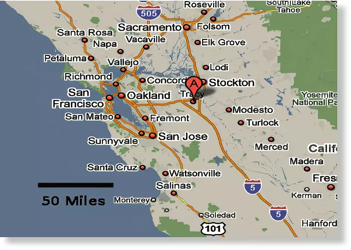
Tracy, California, is a city located in the northern part of the state’s San Joaquin Valley. It serves as a significant residential and commercial hub within the broader San Francisco Bay Area. Understanding Tracy’s geographical location is essential for residents, travelers, and businesses alike.
Geographical Location of Tracy, California
Tracy is situated in San Joaquin County, approximately 60 miles east of San Francisco and 70 miles south of Sacramento. The city lies within a geographic triangle formed by three major interstate highways:
- Interstate 205 (I-205): This highway runs along the northern edge of Tracy, connecting the city to neighboring regions.
- Interstate 5 (I-5): Located to the east, I-5 provides a direct route between Tracy and cities like Stockton and Los Angeles.
- Interstate 580 (I-580): To the southwest, I-580 links Tracy to the Bay Area, including cities like Oakland and San Francisco.
This strategic positioning places Tracy at a crucial intersection for commerce and travel, offering convenient access to various parts of California.
Nearby Cities and Landmarks
Tracy’s proximity to several notable cities and landmarks enhances its appeal:
- Stockton: Located to the east, Stockton is a significant urban center offering diverse cultural and economic opportunities.
- Livermore: To the west, Livermore is known for its wineries and as a gateway to the East Bay region.
- Altamont Pass: Situated to the northwest, this area is recognized for its wind farms and as a critical point in California’s energy production.
Why Tracy’s Location Matters
Tracy’s location has played a significant role in its development and growth. Here’s why:
Proximity to Major Cities
Tracy’s location between San Francisco and Sacramento makes it an ideal place for commuters. Many residents work in the Bay Area but choose to live in Tracy for its more affordable housing and suburban lifestyle. The city is also within driving distance of other major destinations:
- San Francisco: Approximately 1 hour and 15 minutes by car (depending on traffic).
- Sacramento: About 1 hour by car.
- San Jose: Around 1 hour and 30 minutes by car.
- Oakland: Approximately 1 hour by car.
Transportation Hub
Tracy is a key transportation hub due to its proximity to major highways and rail lines. The city is located near:
- Interstate 580 (I-580): Connects Tracy to the Bay Area.
- Interstate 205 (I-205): Links Tracy to Interstate 5 (I-5), a major north-south route.
- Altamont Corridor Express (ACE): A commuter rail service that connects Tracy to San Jose and other Bay Area cities.
This strategic location has made Tracy a center for logistics and distribution, with numerous warehouses and distribution centers located in and around the city.
Agricultural Significance
Tracy is part of the San Joaquin Valley, one of the most productive agricultural regions in the world. The city’s location in this fertile valley has historically made it a center for farming and food production. While Tracy has grown into a suburban community, agriculture remains an important part of its economy and identity.
Conclusion
Tracy, California, is strategically located in the heart of the San Joaquin Valley, offering residents and visitors a blend of small-town charm and big-city accessibility. Its position at the intersection of major highways underscores its importance as a transportation and commercial nexus within the state.

