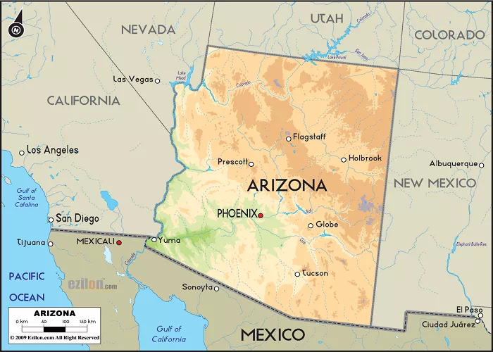
Arizona, located in the southwestern United States, is renowned for its diverse landscapes, iconic natural landmarks, and distinctive geographical features. Understanding Arizona’s appearance on a map provides insight into its unique topography, climatic zones, and cultural significance.
Geographic Location and Borders
Arizona is bordered by four states: Utah to the north, New Mexico to the east, California to the west, and Nevada to the northwest. To the south, it shares an international border with the Mexican state of Sonora. This positioning places Arizona within the Four Corners region, where it meets Utah, Colorado, and New Mexico at a single point—the only such quadripoint in the United States.
State Outline and Shape
On a map, Arizona’s outline resembles a rough quadrilateral, characterized by relatively straight borders with slight deviations:
- Northern Border: Defined by the 37th parallel north, separating Arizona from Utah.
- Eastern Border: Marked by the 109th meridian west, dividing Arizona from New Mexico.
- Western Border: Primarily delineated by the Colorado River, which separates Arizona from California and Nevada.
- Southern Border: Established along the 31st parallel north, adjoining Mexico.
These borders create a shape that is wider in the north and tapers slightly toward the south.
Major Geographic Features
Arizona’s map showcases a variety of geographic features that contribute to its unique landscape:
Grand Canyon
Dominating the north-central part of the state, the Grand Canyon is one of the most recognizable natural landmarks globally. Carved by the Colorado River, it stretches approximately 277 miles in length and attains depths of over a mile, offering breathtaking vistas and geological formations.
Colorado Plateau
Covering the northeastern portion of Arizona, the Colorado Plateau is characterized by high desert landscapes, mesas, and significant geological formations. This region includes notable features such as Monument Valley and the Painted Desert.
Sonoran Desert
Occupying the southwestern part of the state, the Sonoran Desert is distinguished by its arid climate and unique flora, including the iconic saguaro cactus. This desert extends into California and the Mexican state of Sonora.
Mountain Ranges
Arizona hosts several mountain ranges, with the most prominent being:
- San Francisco Peaks: Located north of Flagstaff, these peaks include Humphreys Peak, the state’s highest point at 12,633 feet.
- Mogollon Rim: A significant escarpment running diagonally across the central part of the state, marking the southern edge of the Colorado Plateau.
Rivers and Lakes
Major rivers and lakes depicted on Arizona maps include:
- Colorado River: Forming much of the state’s western boundary and serving as a crucial water source.
- Gila River: Flowing westward across the southern part of the state.
- Salt River: Running through central Arizona and contributing to the Phoenix metropolitan area’s water supply.
- Lake Mead and Lake Powell: Large reservoirs on the Colorado River, straddling the borders with Nevada and Utah, respectively.
Major Cities and Transportation Networks
Arizona’s map highlights several key cities and transportation routes:
- Phoenix: The capital and largest city, situated in the south-central region.
- Tucson: Located in the southeastern part of the state, known for its cultural and historical significance.
- Flagstaff: Nestled in the north-central area, serving as a gateway to the Grand Canyon.
Interstate highways such as I-10, I-17, and I-40 traverse the state, connecting major urban centers and facilitating commerce and travel.
Cultural and Historical Sites
Maps of Arizona also denote various cultural and historical landmarks:
- Navajo Nation and Hopi Reservation: Indigenous territories located in the northeastern part of the state, rich in cultural heritage.
- Historic Route 66: Portions of this iconic highway pass through northern Arizona, with towns like Winslow and Kingman preserving its legacy.
Conclusion
Arizona’s depiction on a map reveals a state of vast contrasts—from deep canyons and high plateaus to expansive deserts and towering mountains. Its distinctive shape and diverse geographic features not only define its physical landscape but also reflect the rich cultural tapestry and historical significance that make Arizona a unique and captivating part of the United States.

