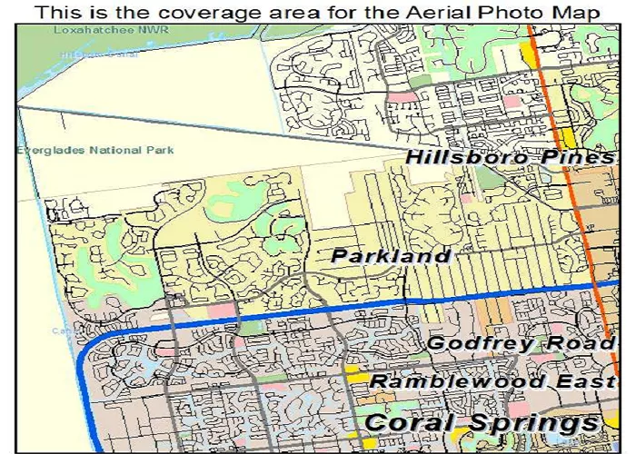
Parkland, Florida is a distinctive suburban community that exemplifies thoughtful urban planning and high quality living standards in South Florida. Nestled in northern Broward County, this carefully designed municipality offers an interesting case study of modern American suburban development. This comprehensive guide examines Parkland’s geographical context, historical evolution, demographic composition, economic characteristics, and environmental features through detailed analysis and current data.
Precise Geographic Positioning
Coordinates and Regional Context
Absolute Location: 26.3162° N, 80.2515° W
Elevation: 16 feet (4.9 meters) above sea level
Relative Position:
-
- 12 miles northwest of Fort Lauderdale
- 38 miles north of Miami
- 8 miles west of Pompano Beach
Municipal Boundaries and Size
Total Area: 12.3 square miles (31.9 km²)
Border Communities:
-
- Coral Springs (south)
- Boca Raton (north)
- Coconut Creek (east)
- Loxahatchee Wildlife Refuge (west)
Transportation Infrastructure
| Route | Type | Significance |
|---|---|---|
| SR-7/US-441 | Arterial | Primary north-south corridor |
| Hillsboro Blvd | County road | Main east-west thoroughfare |
| Sawgrass Expy | Toll road | Regional connector |
Historical Development
Timeline of Growth
- 1960s: Originally pineapple farms and wetlands
- 1963: First planned community established
- 1967: Officially incorporated as a city
- 1990s-2000s: Major residential expansion
Planning and Zoning Philosophy
Development Principles:
-
- Minimum 2-acre residential lots (originally)
- 20% mandatory green space
- Strict architectural controls
Growth Management:
-
- Phased expansion
- Cluster development approach
Demographic Profile
Population Characteristics
| Metric | Parkland | Florida Average |
|---|---|---|
| Population (2023) | 34,670 | – |
| Median Age | 41.2 | 42.2 |
| Household Income | $172,891 | $61,777 |
Cultural Composition
Ethnic Distribution:
-
- 78% White
- 12% Hispanic
- 6% Asian
- 3% Black
Educational Attainment:
-
- 65% bachelor’s degree or higher
- 92% high school graduates
Economic Landscape
Employment and Industries
| Sector | % Workforce | Key Employers |
|---|---|---|
| Professional | 34% | Healthcare systems |
| Education | 22% | Broward Schools |
| Retail | 15% | The Shops at Parkland |
Housing Market
Residential Characteristics:
-
- 10,487 housing units
- 92% single-family homes
Market Trends:
-
- Median home value: $850,000
- Average price per sq ft: $325
Environmental Features
Natural Resources
Water Systems:
-
- 7 major lakes
- 12 miles of canals
Green Spaces:
-
- 22 public parks
- 35 miles of trails
Conservation Efforts
| Program | Description | Impact |
|---|---|---|
| Tree Preservation | 45% canopy coverage | 3°F cooling effect |
| Wildlife Corridors | 8 designated pathways | Protects 42 species |
Community Amenities
Education System
Public Schools:
-
- 8 A-rated schools
- 1 nationally ranked high school
Higher Education:
-
- 3 university satellite campuses
Recreational Facilities
| Type | Quantity | Annual Usage |
|---|---|---|
| Sports Fields | 18 | 500,000 visits |
| Community Centers | 4 | 200,000 visits |
Conclusion
Parkland’s strategic location at the intersection of Broward and Palm Beach counties has allowed it to develop as one of Florida’s most desirable residential communities. The city demonstrates how strict zoning regulations and environmental consciousness can create sustainable suburban living spaces while maintaining high property values. Its continued appeal lies in balancing growth with preservation, offering residents both accessibility to urban centers and retreat-like tranquility.

