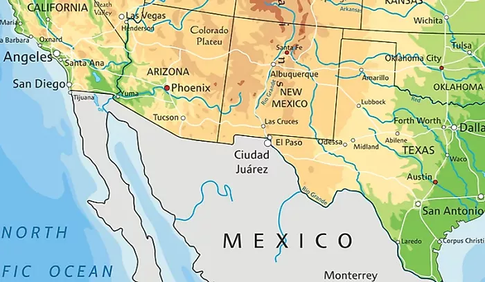
New Mexico is a state in the southwestern United States. It is known for its diverse landscapes, rich history, and cultural heritage. New Mexico shares its borders with four U.S. states: Colorado to the north, Oklahoma and Texas to the east, and Arizona to the west. Additionally, it shares an international border with the Mexican states of Chihuahua and Sonora to the south.
1. Colorado
Location and Length of the Border
New Mexico shares its northern border with Colorado. The border runs east to west and is approximately 330 miles long.
Key Cities and Landmarks Near the Border
- Ratón, NM: A small city near the Colorado border, known for the Ratón Pass.
- Trinidad, CO: Just across the border, this historic town was an important stop on the Santa Fe Trail.
Geographical Features
The border region includes parts of the Rocky Mountains. The Raton Mesa and Sangre de Cristo Mountains are notable features.
Historical Significance
The border was established by the Compromise of 1850, which defined the boundaries of New Mexico Territory.
2. Oklahoma
Location and Length of the Border
New Mexico’s border with Oklahoma is small—only about 2 miles long. It is located in the northeastern part of New Mexico.
Key Cities and Landmarks Near the Border
- Texhoma: A small town split between Texas and Oklahoma, near the New Mexico border.
Geographical Features
This area is mostly flat and part of the Great Plains.
Historical Significance
The border was set by the Adams-Onís Treaty (1819) between the U.S. and Spain.
3. Texas
Location and Length of the Border
New Mexico shares its longest border with Texas—about 688 miles. This border runs along the eastern and southeastern parts of New Mexico.
Key Cities and Landmarks Near the Border
- El Paso, TX: A major city near the southern part of the border.
- Clovis, NM: A city in eastern New Mexico close to Texas.
Geographical Features
The border crosses the Llano Estacado (a large plateau) and the Pecos River.
Historical Significance
The border was disputed until the Compromise of 1850 settled it.
4. Arizona
Location and Length of the Border
The border with Arizona is about 389 miles long and runs along the western side of New Mexico.
Key Cities and Landmarks Near the Border
- Gallup, NM: Known as the “Heart of Indian Country.”
- Window Rock, AZ: The capital of the Navajo Nation.
Geographical Features
The border region includes parts of the Colorado Plateau and the Painted Desert.
Historical Significance
The border was defined when Arizona became a separate territory from New Mexico in 1863.
International Border with Mexico
To the south, New Mexico shares an international border with the Mexican states of Chihuahua and Sonora. This boundary spans approximately 180 miles and includes desert and mountainous terrains. The border region is significant for trade, cultural exchange, and immigration. Key border crossings include the cities of Columbus, New Mexico, and Palomas, Chihuahua.
Conclusion
New Mexico’s borders with Colorado, Oklahoma, Texas, Arizona, and Mexico contribute to its unique geographical and cultural identity. The state’s location at the crossroads of various regions has fostered a rich tapestry of landscapes, histories, and communities.

