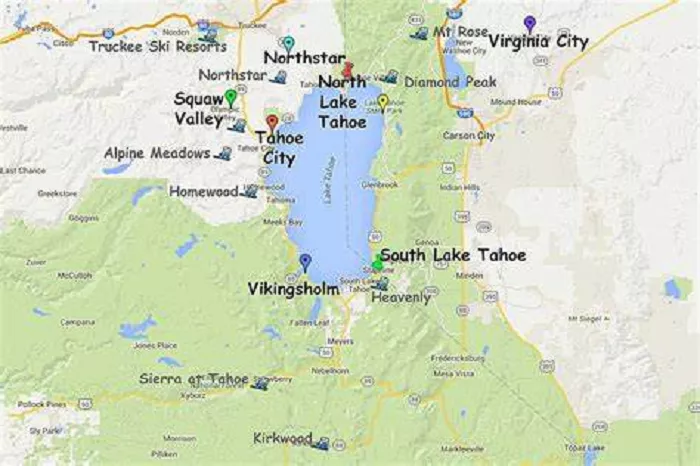
The journey from Lake Tahoe to Reno, Nevada, offers travelers a blend of natural beauty, recreational opportunities, and cultural experiences. Understanding the route, landmarks, and attractions along the way enhances the travel experience. This guide provides detailed information to assist in planning your trip.
Lake Tahoe, straddling the border between California and Nevada, is renowned for its clear waters and year-round recreational activities. Approximately 63 miles (101 kilometers) northeast lies Reno, known as “The Biggest Little City in the World,” celebrated for its vibrant arts scene and casinos. The route connecting these two destinations is not just a drive but a journey through diverse landscapes and attractions.
Geographic Overview
- Lake Tahoe
- Location: Straddles California and Nevada
- Coordinates: 39.0968° N, 120.0324° W
- Size: 22 miles long, 12 miles wide (largest alpine lake in North America)
- Closest Major City: Reno, NV (45-minute drive)
- Reno, Nevada
- Location: In Washoe County, near the California border
- Coordinates: 39.5296° N, 119.8138° W
- Nickname: “The Biggest Little City in the World”
- Elevation: 4,505 feet (1,373 meters)
Distance Between Lake Tahoe and Reno
| Route | Distance | Drive Time |
|---|---|---|
| I-580 S → US-395 S → NV-431 W (Mount Rose Highway) | 40 miles | ~45 minutes |
| I-80 W → CA-89 S (Truckee Route) | 55 miles | ~1 hour |
Starting Point: Lake Tahoe
- Incline Village: Begin your journey at Incline Village, a charming community offering lakeside views and access to local beaches.
Route Details
- Mount Rose Highway (SR 431): Travel east on SR 431, ascending the Carson Range with opportunities to stop at overlooks for panoramic views of Lake Tahoe and the surrounding mountains.
- Mount Rose Summit: At an elevation of 8,911 feet, this is the highest year-round pass in the Sierra Nevada. The summit area offers hiking trails and seasonal ski resorts.
- Descent into Reno: As you descend, the landscape transitions from alpine forests to the high desert, leading into the urban environment of Reno.
Attractions Along the Route
- Mount Rose Ski Tahoe: Located near the summit, this ski resort offers winter sports and summer hiking opportunities.
- Galena Creek Recreation Area: A great spot for picnics, fishing, and educational programs about the local ecosystem.
- Reno’s Riverwalk District: Upon arrival, explore this vibrant area filled with art galleries, restaurants, and shops along the Truckee River.
Travel Tips
- Road Conditions: The Mount Rose Highway is generally open year-round, but winter travelers should be prepared for snow and carry chains if required.
- Fuel and Supplies: Ensure your vehicle is fueled, and you have necessary supplies, as services are limited along the highway.
- Time of Travel: The drive typically takes about 1.5 to 2 hours, but plan extra time for stops and sightseeing.
Conclusion
The journey from Lake Tahoe to Reno via the Mount Rose Highway is more than just a commute; it’s an opportunity to experience Nevada’s diverse landscapes and attractions. Whether you’re seeking outdoor adventures, cultural experiences, or simply a scenic drive, this route offers something for every traveler.

