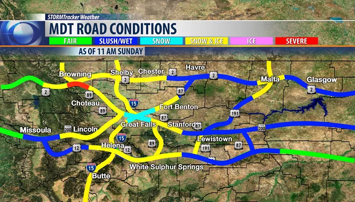
Montana, affectionately known as “Big Sky Country,” offers travelers expansive plains, majestic mountains, and picturesque valleys. However, its vast landscapes also bring a variety of weather conditions that can significantly influence road travel. Understanding these conditions and effectively utilizing weather road maps are essential for ensuring a safe and enjoyable journey through the state.
What is Montana’s Climate
Geographical Influences
Montana’s extensive size and diverse topography play a crucial role in its climatic conditions. The state stretches from the Canadian border in the north to the Wyoming border in the south, encompassing elevations ranging from approximately 2,000 feet to over 12,000 feet. This variation leads to distinct climate zones:
- Western Montana: Characterized by mountainous regions, this area experiences significant precipitation, especially in the form of snow during winter months.
- Eastern Montana: Comprising vast plains, this region faces more extreme temperature variations, with hot summers and cold winters.
Seasonal Variations
Montana experiences four distinct seasons, each bringing unique weather patterns:
- Spring (March to May): Temperatures gradually rise, but snowstorms remain possible, particularly in northern regions.
- Summer (June to August): Warm temperatures prevail, with occasional thunderstorms, especially in the afternoons.
- Fall (September to November): Cooling temperatures and the onset of snow in higher elevations mark this season.
- Winter (December to February): Cold temperatures dominate, with heavy snowfall common, leading to challenging road conditions.
Major Roadways in Montana
Interstate Highways
Montana’s interstate highways are vital for cross-state travel:
- Interstate 15 (I-15): Running north-south, I-15 connects cities like Great Falls and Butte. Travelers should be aware of potential weather-related road closures, especially during winter months.
- Interstate 90 (I-90): Stretching east-west, I-90 links cities such as Billings, Bozeman, and Missoula. It’s crucial to monitor road conditions, as snow and ice can lead to hazardous travel.
Scenic Byways
Beyond interstates, Montana boasts scenic routes that showcase its natural beauty:
- Going-to-the-Sun Road: Located in Glacier National Park, this 50-mile route offers breathtaking views but is susceptible to late openings due to heavy snow accumulation. The road is generally open from early June to mid-October, with its latest opening on July 13, 2022.
- Beartooth Highway: Connecting Red Lodge, Montana, to Cooke City near Yellowstone’s northeast entrance, this highway reaches elevations over 10,900 feet and is renowned for its stunning vistas. It’s typically open from mid-May to mid-October, weather permitting.
The Importance of Weather Road Maps
Weather road maps are indispensable tools for travelers in Montana, offering:
Real-Time Updates
These maps provide current information on road conditions, closures, and weather advisories, enabling travelers to make informed decisions and adjust plans as necessary.
Planning and Safety
By studying weather road maps before and during travel, individuals can identify potential hazards, plan alternative routes, and ensure they are adequately prepared for changing conditions.
Utilizing Montana’s Road Condition Resources
Montana Department of Transportation (MDT)
The MDT offers comprehensive resources for travelers:
- MDT Road Condition Map: An interactive tool displaying real-time road conditions, closures, and traffic incidents across Montana. This map is essential for pre-trip planning and en-route updates.
- MDT Traveler Information Line: A dedicated hotline providing up-to-date information on road conditions, closures, and travel advisories. Travelers can contact the line at 1-800-226-7623 or dial 511 for real-time updates.
- MDT Webcams: Strategically placed cameras offer live views of road conditions, helping travelers assess current situations before and during their journey.
Navigating Montana’s Scenic Routes
Going-to-the-Sun Road
This iconic road traverses Glacier National Park, providing travelers with unparalleled views of the Rocky Mountains, alpine lakes, and diverse wildlife. Due to heavy snowfall, the road’s opening date varies each year, typically between late June and mid-July. It’s advisable to check the current status before planning your trip.
Beartooth Highway
Recognized as one of America’s most scenic drives, the Beartooth Highway connects Red Lodge, Montana, to Cooke City near Yellowstone’s northeast entrance. The route reaches elevations over 10,900 feet and is renowned for its breathtaking vistas. It’s typically open from mid-May to mid-October, but travelers should verify current road conditions before traveling.
Best Practices for Traveling in Montana
Preparation
- Check Weather Forecasts: Before your trip, review weather forecasts for both your departure and destination points, as well as the routes in between.
- Review Road Conditions: Utilize the MDT Road Condition Map and traveler information line to stay informed about current road statuses.
- Equip Your Vehicle: Ensure your vehicle is equipped with essentials such as tire chains, a spare tire, jumper cables, and warm clothing, especially during winter months.
Conclusion
Montana’s weather can change fast, making a weather road map essential for travelers. By understanding seasonal risks and checking real-time updates, you can enjoy Montana’s stunning landscapes safely.
Whether you’re cruising Going-to-the-Sun Road in summer or navigating I-90 in winter, staying informed ensures a smooth journey through Big Sky Country.

