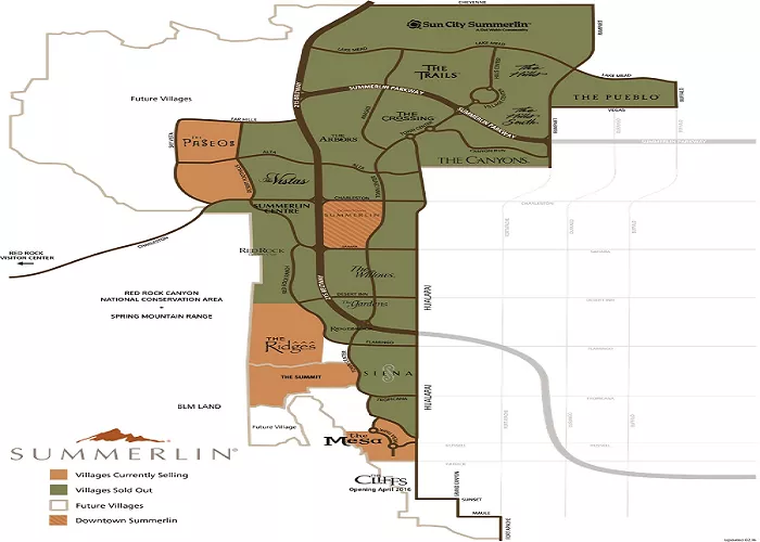
Summerlin is a master-planned community located in the western part of Las Vegas, Nevada. Developed by The Howard Hughes Corporation, it spans approximately 22,500 acres and offers a blend of residential, commercial, and recreational spaces. Understanding the layout of Summerlin is essential for residents, visitors, and potential homebuyers. This article provides a detailed overview of Summerlin’s geography, neighborhoods, amenities, and resources for accessing comprehensive maps.
A detailed map of Summerlin serves as a valuable tool for navigating its diverse neighborhoods, locating amenities, and understanding the community’s layout. Whether you’re planning a visit, considering relocation, or simply curious about the area, having access to accurate and detailed maps enhances your experience.
Geographical Overview of Summerlin
Situated along the western edge of Las Vegas, Summerlin is bordered by the Spring Mountains to the west and the Red Rock Canyon National Conservation Area to the northwest. Its boundaries are generally defined by:
- North: Cheyenne Avenue
- South: Sahara Avenue
- East: Interstate 215 (I-215) Beltway
- West: The western edge aligns with the Red Rock Canyon conservation area
These boundaries encompass a variety of terrains, from urban developments to natural desert landscapes.
Neighborhoods and Villages
Summerlin is organized into several villages, each offering unique characteristics and amenities. A clickable map of these villages can be found here:
Notable Villages and Their Features
- The Ridges: An exclusive, guard-gated community known for luxury custom homes and proximity to the Bear’s Best Golf Course.
- Red Rock Country Club: Features a private golf club and upscale residences with scenic views of the Red Rock Canyon.
- Sun City Summerlin: A 55+ active adult community offering numerous amenities tailored for senior living.
- The Paseos: Characterized by modern homes and extensive walking trails, emphasizing an active lifestyle.
- The Willows: Offers a serene environment with lush landscaping and proximity to parks.
For a comprehensive list of neighborhoods within each village, refer to this guide:
Amenities and Attractions
Summerlin boasts a wide array of amenities designed to enhance the quality of life for its residents. These include:
- Parks and Recreation: Over 150 parks, numerous sports fields, and miles of walking and biking trails.
- Community Centers: Facilities offering fitness centers, swimming pools, and event spaces.
- Golf Courses: Multiple championship golf courses catering to enthusiasts of all skill levels.
- Shopping and Dining: The Downtown Summerlin® area features a variety of retail stores, restaurants, and entertainment options.
- Schools: The community is served by the Clark County School District, offering several public and charter schools.
Detailed maps highlighting these amenities can be accessed here:
Accessing Detailed Maps
For residents and visitors seeking detailed maps of Summerlin, the following resources are recommended:
- Summerlin Official Website: Provides various maps, including:
- Actively Selling Map: Shows current residential developments.
- Apartment Guide Map: Highlights apartment complexes within Summerlin.
- Amenities Map: Displays parks, trails, and recreational facilities.
- Summerlin Border Map: Outlines the community’s boundaries.
- SID Map: Details Special Improvement Districts.
- Trails Map: Illustrates the extensive network of trails.
- Cell Tower Sites: Identifies locations of cell towers for coverage information.
- HOA Map: Provides information on Homeowners Association boundaries.
Access these maps here:
- City of Las Vegas Planning and Development Department: Offers land use maps and other planning resources. One such map is the Summerlin Land Use Map, which provides insights into zoning and land designations. View it here:
Utilizing Maps for Navigation and Exploration
While digital mapping services like Google Maps and Apple Maps offer general navigation, specialized maps provide more detailed information about Summerlin’s unique features. For instance, trail maps are invaluable for hikers and cyclists exploring the community’s extensive network, while amenity maps assist in locating parks, community centers, and recreational facilities.
Future Developments
Summerlin continues to evolve, with ongoing developments introducing new neighborhoods, amenities, and infrastructure enhancements. Staying updated with the latest maps and information is essential for residents and those interested in the community’s growth. Regularly visiting the official Summerlin website and engaging with local news sources will provide the most current insights.
Conclusion
A detailed map of Summerlin, Nevada, is an indispensable resource for understanding the community’s layout, accessing amenities, and navigating its diverse neighborhoods. By utilizing the resources provided above, individuals can gain a comprehensive understanding of what Summerlin has to offer, ensuring a seamless and informed experience within this vibrant master-planned community.

