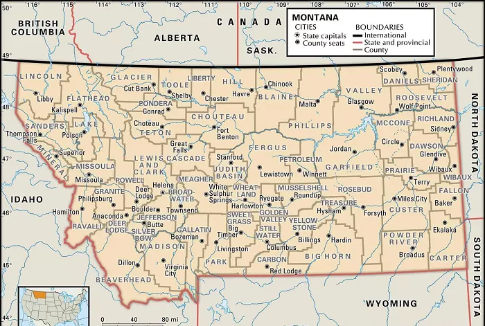
Montana, often referred to as “Big Sky Country,” is the fourth-largest state in the United States, encompassing a vast expanse of diverse landscapes. To facilitate governance, administration, and service delivery, Montana is divided into 56 counties, each with its unique characteristics and administrative functions. Understanding the county divisions is essential for residents, visitors, and those interested in the state’s geography.
A county map of Montana provides a visual representation of the state’s administrative divisions, highlighting the boundaries, county seats, and geographical features. Such maps are invaluable for navigation, planning, and gaining insights into the state’s regional distinctions.
Overview of Montana’s Counties
Montana’s 56 counties vary significantly in size, population, and historical significance. Some counties, like Beaverhead, are expansive in land area, while others, such as Petroleum, have smaller populations. The counties serve as essential units for local governance, law enforcement, and public services.
Detailed County Map of Montana
For a comprehensive view of Montana’s counties, including their boundaries and county seats, the following resources are recommended:
- Montana State Library – County Maps: This resource provides access to pre-built map series for each of Montana’s counties, available in Adobe PDF format.
- Montana Sheriffs and Peace Officers Association – County Map: This interactive map offers a detailed view of all counties, allowing users to click on individual counties for more information.
- Geology.com – Montana County Map: This map displays county boundaries with county seats and includes a satellite image of Montana with county outlines.
Historical Context
The boundaries and names of Montana’s counties have evolved over time. For a deep dive into the historical boundaries, names, and organizational changes of every county, including extinct counties and unsuccessful proposals, the Newberry Atlas of Historical County Boundaries offers an interactive map and detailed textual information.
Utilizing County Maps
County maps are essential tools for various purposes:
- Navigation: They assist travelers in planning routes and understanding regional layouts.
- Administrative Functions: Government agencies use these maps for electoral processes, resource distribution, and public service delivery.
- Educational Purposes: Students and researchers utilize county maps for academic studies related to geography, history, and social sciences.
Regions and Statistical Areas
Montana is also categorized into several regions and statistical areas that provide insights into its demographic and economic landscapes.
Core-Based Statistical Areas (CBSAs)
The Office of Management and Budget (OMB) has delineated seven core-based statistical areas in Montana, comprising metropolitan and micropolitan regions:
- Billings, MT Metropolitan Statistical Area (MSA): Includes Yellowstone, Carbon, and Stillwater counties, with Billings as the principal city.
- Missoula, MT MSA: Comprises Missoula and Mineral counties, centered around the city of Missoula.
- Bozeman, MT MSA: Encompasses Gallatin County, with Bozeman as the core city.
- Kalispell, MT Micropolitan Statistical Area (μSA): Consists of Flathead County, with Kalispell as the central city.
- Helena, MT MSA: Includes Lewis and Clark, Jefferson, and Broadwater counties, with Helena as the principal city.
- Great Falls, MT MSA: Comprises Cascade County, centered around Great Falls.
- Butte-Silver Bow, MT μSA: Encompasses Silver Bow County, with Butte as the central city.
Regions of Montana
Beyond administrative boundaries, Montana is often divided into regions that highlight cultural, historical, and geographical distinctions:
Glacier Country
Located in western Montana, Glacier Country includes eight counties:
- Flathead County: Home to Kalispell and Whitefish, and the western side of Glacier National Park.
- Glacier County: Contains the eastern side of Glacier National Park and lands within the Blackfeet Indian Reservation.
- Lake County: Encompasses the southern half of Flathead Lake and portions of the Flathead Indian Reservation.
- Lincoln County: Includes the city of Libby and diverse natural landscapes.
- Mineral County: Features the county seat of Superior and rich natural resources.
- Missoula County: Houses the city of Missoula, the state’s second-largest city, and various unincorporated communities.
- Ravalli County: Known for the Bitterroot Valley and the city of Hamilton.
- Sanders County: Includes the city of Thompson Falls and parts of the Flathead Indian Reservation.
Conclusion
Montana’s county map serves as a vital tool for understanding the state’s administrative structure and geographical nuances. Whether for navigation, administrative tasks, or educational pursuits, these maps provide clarity and insight into the diverse regions of “Big Sky Country.”

