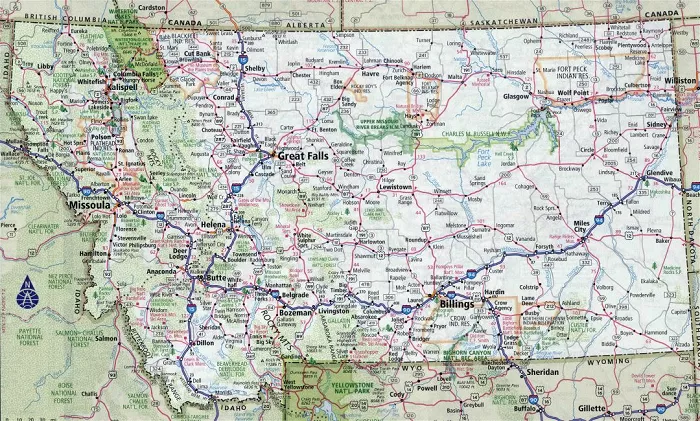
Montana, known as “Big Sky Country,” boasts expansive landscapes, diverse terrains, and a network of roads and highways that connect its cities, towns, and natural wonders. Understanding Montana’s road system is essential for residents, travelers, and geography enthusiasts alike.
Montana, the fourth-largest state in the U.S., spans over 147,000 square miles. Its road network is designed to cater to both local traffic and the influx of tourists exploring its vast wilderness and attractions.
Overview of Montana’s Road System
Montana’s roads can be broadly categorized into:
- Interstate Highways: Major routes facilitating long-distance travel across the state.
- U.S. Highways: Primary roads connecting various regions within Montana and neighboring states.
- State Highways: Roads maintained by the state, linking smaller towns and rural areas.
- County Roads: Local roads serving individual counties and municipalities.
Major Highways in Montana
Interstate Highways
- Interstate 15 (I-15): Running north-south, I-15 connects cities like Great Falls and Butte, extending from the Canadian border in the north to the Mexican border in the south.
- Interstate 90 (I-90): The longest interstate highway, I-90 traverses the state east-west, linking cities such as Missoula, Butte, and Billings.
- Interstate 94 (I-94): A shorter east-west route, I-94 passes through the eastern part of the state, connecting cities like Glendive and Miles City.
U.S. Highways
- U.S. Highway 2 (US 2): An east-west route that stretches across the northern part of the state, connecting towns like Kalispell and Glasgow.
- U.S. Highway 12 (US 12): Running parallel to the Yellowstone River, US 12 connects towns such as Lolo and Wibaux.
- U.S. Highway 87 (US 87): A north-south route linking cities like Billings and Great Falls.
State Highways
- Montana Highway 200 (MT 200): An east-west highway connecting towns like Missoula and Jordan.
- Montana Highway 287 (MT 287): Running north-south, MT 287 connects towns such as Ennis and Three Forks.
Road Conditions and Travel Information
Montana’s vast landscapes can present diverse weather conditions, especially during winter months. It’s crucial for travelers to stay updated on road conditions and travel advisories.
- Montana Department of Transportation (MDT): Provides comprehensive maps, road condition updates, and travel information.
- 511MT: A travel information system offering real-time road conditions, traffic updates, and travel alerts.
Detailed Road Maps
For a comprehensive understanding of Montana’s road network, detailed maps are invaluable:
- Montana Highway Map: The MDT publishes an official highway map highlighting interstates, U.S. highways, state routes, and major cities.
- Interactive Map Gallery: MDT offers interactive maps showcasing road conditions, traffic incidents, and more.
- Highway Map Routes: Explore scenic routes and travel ideas across Montana with detailed maps provided by the Montana Office of Tourism.
Scenic Drives and Attractions
Montana’s roadways not only connect cities but also offer access to some of the nation’s most beautiful landscapes and attractions:
- Beartooth Highway: An All-American Road connecting Red Lodge to the northeast entrance of Yellowstone National Park, offering breathtaking views of the Beartooth Plateau.
- Going-to-the-Sun Road: A scenic drive through Glacier National Park, crossing the Continental Divide and providing panoramic views of the Rockies.
- Route of the Hiawatha: A 15-mile bike trail through the Bitterroot Mountains, featuring tunnels and trestles from the old Milwaukee Railroad.
Conclusion
Montana’s road system is a testament to its rich history, diverse geography, and commitment to connectivity. Whether you’re a resident commuting daily or a traveler exploring the vast terrains, understanding the state’s road network enhances the experience. Always prioritize safety, stay informed about current road conditions, and enjoy the journey through Big Sky Country.

