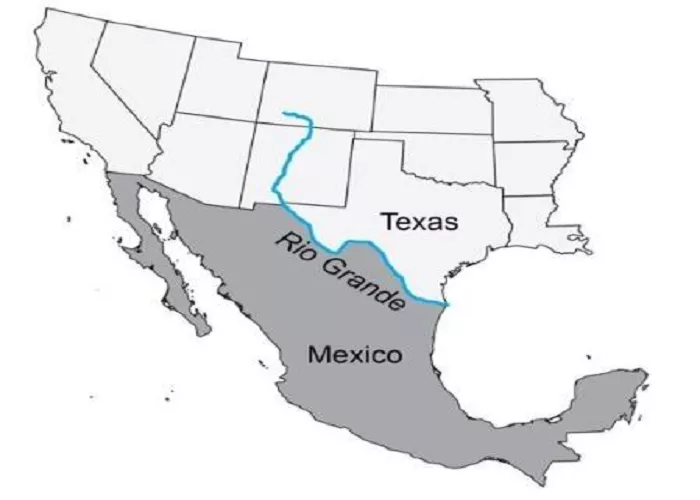
The Rio Grande, also known as the Río Bravo del Norte in Mexico, is the river that forms the natural border between the U.S. state of Texas and Mexico. Stretching approximately 1,900 miles (3,060 kilometers), it ranks as the fifth-longest river in North America and the twentieth-longest globally.
The Rio Grande: The River That Divides Two Nations
1. What Is the Name of the River?
The river separating Texas from Mexico is the Rio Grande (called Río Bravo del Norte in Mexico). It is one of the longest rivers in North America, flowing 1,896 miles from Colorado to the Gulf of Mexico.
2. Where Does the Rio Grande Form the Border?
The Rio Grande serves as the natural border between Texas and Mexico for 1,255 miles, starting near El Paso, Texas, and ending at the Gulf of Mexico.
Key Texas cities along the river:
- El Paso (borders Ciudad Juárez, Mexico)
- Laredo (borders Nuevo Laredo, Mexico)
- Brownsville (borders Matamoros, Mexico)
3. How Was the Rio Grande Chosen as the Border?
The U.S. and Mexico officially recognized the Rio Grande as the border after the:
- Treaty of Guadalupe Hidalgo (1848) – Ended the Mexican-American War, giving the U.S. Texas, California, and other territories.
- Gadsden Purchase (1853) – Adjusted the border slightly, confirming the Rio Grande as the boundary.
Before this, the Nueces River (further north) was claimed by Mexico as the border, leading to disputes.
Geographical Significance
The Rio Grande serves as a crucial geographical feature, delineating political boundaries and providing essential water resources to the surrounding regions. In Texas, it defines the state’s southern border, separating it from the Mexican states of Chihuahua, Coahuila, Nuevo León, and Tamaulipas. This river not only influences the political landscape but also significantly impacts the cultural and economic interactions between the two countries.
Historical Importance of the Rio Grande
1. Native American and Spanish Colonial Era
- Tribes like the Comanche and Apache lived near the river.
- Spanish explorers (like Cabeza de Vaca) crossed it in the 1500s.
2. The Mexican-American War (1846–1848)
- A key dispute was whether the Nueces River or Rio Grande was the border.
- The U.S. argued for the Rio Grande, leading to war.
3. Modern Conflicts and Immigration
- The river is a major crossing point for migrants entering the U.S.
- Border patrols and walls have been built along parts of the river.
Tributaries and Watershed
The Rio Grande’s watershed encompasses a diverse range of tributaries that contribute to its flow and ecological significance. Major tributaries include the Pecos River and the Devils River from the north, and the Rio Conchos from the south. These tributaries play vital roles in supporting the river’s ecosystem and supplying water to the arid regions through which the Rio Grande flows.
Environmental and Economic Importance
Beyond its role as a political boundary, the Rio Grande is indispensable to the environment and economy of the border regions. It provides water for agricultural irrigation, sustains local ecosystems, and supports recreational activities. However, the river has faced challenges such as reduced flow due to water usage and periodic droughts, leading to concerns about water scarcity and environmental degradation.
Conclusion
The Rio Grande is more than just a river; it is a lifeline that shapes the history, culture, and livelihoods of the communities along its banks. Understanding its course, tributaries, and significance is essential for appreciating the complex relationship between Texas and Mexico. As both a natural resource and a cultural symbol, the Rio Grande continues to influence the lives of millions, underscoring the need for collaborative efforts to preserve and protect this vital waterway.

