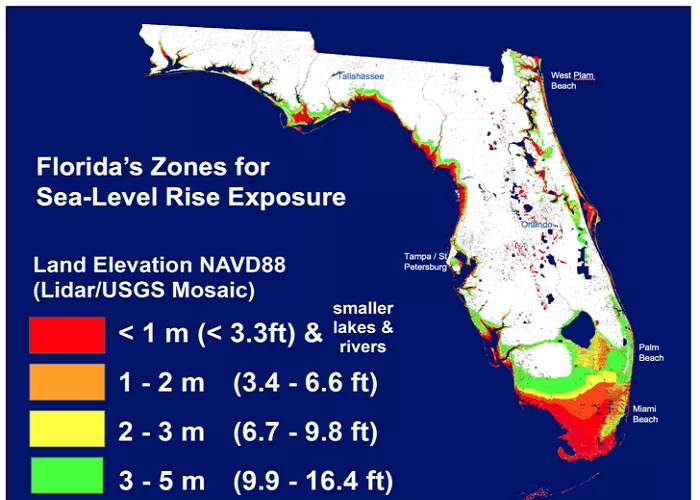
South Florida’s unique landscape, characterized by its flat terrain and coastal features, is best understood through detailed topographic maps. These maps provide a visual representation of the area’s elevation changes, water bodies, and human-made structures, offering valuable insights for various applications, from urban planning to environmental studies.
What is Topographic Maps
Topographic maps are detailed, accurate graphic representations of the Earth’s surface. They depict terrain relief, showing elevation changes through contour lines, which are lines connecting points of equal elevation. In addition to elevation, these maps illustrate natural features like rivers, lakes, and forests, as well as man-made features such as roads, buildings, and boundaries.
Key Features of South Florida’s Topography
1. The Everglades: A Slow-Moving “River of Grass”
- Average elevation: 0 to 8 feet above sea level
- Contour lines show almost no variation—indicating extremely flat terrain.
- Water flow moves slowly southward from Lake Okeechobee to Florida Bay.
2. The Atlantic Coastal Ridge
- Location: Parallel to the east coast (Miami to Palm Beach)
- Highest points: Up to 25 feet in some areas (e.g., Miami Rock Ridge)
- Importance: Protects inland areas from storm surges.
3. The Florida Keys
- Composed of ancient coral reefs with minimal elevation (3–18 feet).
- Low-lying islands are highly vulnerable to hurricanes.
4. Big Cypress Swamp
- Northwest of the Everglades, slightly higher elevation (5–12 feet).
- Critical for water storage during wet seasons.
5. Urban Areas (Miami, Fort Lauderdale, Naples)
- Built on drained wetlands, often just 1–6 feet above sea level.
- Artificial elevations (like highways and landfills) appear on maps as “high points.”
South Florida’s Terrain and Elevation
South Florida is predominantly flat, with its highest point, Britton Hill, reaching just 345 feet (105 meters) above sea level. This gentle topography is evident in color-coded shaded relief maps, where green indicates low elevations, transitioning to yellow, tan, and white at higher elevations.
Importance of Topographic Maps in South Florida
Topographic maps of South Florida serve multiple purposes:
- Urban Planning and Development: They assist in designing infrastructure by highlighting elevation changes, flood-prone areas, and suitable construction sites.
- Environmental Conservation: These maps identify natural habitats, water bodies, and ecosystems, aiding in conservation efforts and resource management.
- Recreation and Tourism: Hikers, bikers, and tourists use topographic maps to navigate trails, parks, and recreational areas, ensuring safe and enjoyable experiences.
Accessing South Florida Topographic Maps
Several resources provide access to detailed topographic maps of South Florida:
- Florida Department of Environmental Protection (DEP): The DEP offers datasets representing land surface elevation at a 1:24,000 scale for Florida, which can be useful for creating topographic maps.
- USGS TopoView: This platform allows users to explore both current and historical USGS topographic maps, offering a comprehensive view of South Florida’s terrain over time.
- The National Map Viewer: Provided by the U.S. Geological Survey, this tool enables users to access and download topographic maps, including those of South Florida.
Utilizing Topographic Maps for Various Applications
- Urban Planning: Planners and developers use topographic maps to assess land suitability for construction, identify flood zones, and plan infrastructure projects.
- Environmental Studies: Researchers analyze these maps to study watershed boundaries, wetlands, and habitats, supporting conservation and restoration initiatives.
- Outdoor Activities: Enthusiasts rely on topographic maps to locate trails, campsites, and points of interest, enhancing their recreational experiences.
Conclusion
Topographic maps are invaluable tools for understanding and navigating South Florida’s landscape. They provide essential information for planning, environmental management, and recreation, contributing to the region’s sustainable development and enjoyment.

