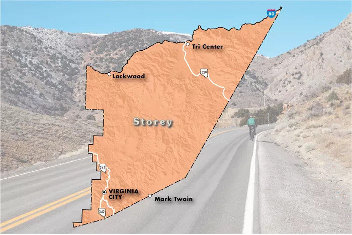
Storey County is a small county located in the state of Nevada, USA. It is known for its rich history, scenic landscapes, and significant economic developments. Understanding the geography and layout of Storey County through maps can provide valuable insights into its communities, historical sites, and economic centers.
Overview of Storey County
Storey County was established in 1861 and named after Captain Edward Farris Storey, who was killed in the Pyramid Lake War. It is the smallest county in Nevada by area, covering approximately 264 square miles (683 square kilometers). Despite its small size, the county has played a significant role in Nevada’s history, particularly during the mining boom of the 19th century.
Geographic Location
Storey County is situated in the western part of Nevada. It is bordered by Washoe County to the north, Lyon County to the southeast, and Carson City to the southwest. The county’s proximity to Reno and Sparks makes it part of the Reno-Sparks metropolitan area.
Major Highways
Several major highways run through Storey County, providing vital transportation routes:
- Interstate 80 (I-80): This major east-west highway crosses the northern part of the county, facilitating travel and commerce between Reno and other regions.
- State Route 341 (SR 341): Also known as the Virginia City Highway, SR 341 connects Reno to Virginia City, offering scenic views of the surrounding mountains.
- State Route 342 (SR 342): This route serves as a connector between SR 341 and the historic town of Gold Hill.
- State Route 439 (SR 439): Known as USA Parkway, this highway provides access to the Tahoe-Reno Industrial Center.
Communities within Storey County
Storey County comprises several communities, each with its unique characteristics:
Virginia City
Virginia City is the county seat and the largest community in Storey County. It gained prominence during the Comstock Lode silver discovery in 1859, which led to a mining boom. Today, Virginia City preserves much of its historic charm, attracting tourists interested in its rich heritage.
Gold Hill
Located just south of Virginia City, Gold Hill was also established during the mining boom. It is home to the Gold Hill Hotel and Saloon, the oldest hotel in Nevada, offering visitors a glimpse into the past.
Lockwood
Situated along the Truckee River, Lockwood is a residential community known for its serene environment. It includes amenities such as a community center, elementary school, and local businesses.
Mark Twain
The Mark Twain area is located at the base of Six Mile Canyon. It features rural residential properties, primarily consisting of mobile and manufactured homes on large plots of land.
Virginia City Highlands
This unincorporated area lies north of Virginia City and offers custom estate homes on expansive lots. The region is characterized by rolling hills and pinyon pines, providing a picturesque rural setting.
Painted Rock
Located along the Truckee River and Interstate 80 corridor, Painted Rock is a rural area with agricultural roots. Its proximity to the Tahoe-Reno Industrial Center makes it suitable for future mixed-use residential development.
McCarran (Tahoe-Reno Industrial Center)
McCarran is home to the Tahoe-Reno Industrial Center (TRIC), one of the largest industrial parks in the United States. Covering over 107,000 acres, TRIC hosts more than a hundred companies, including major firms like Tesla, Panasonic, and Walmart. The industrial center significantly contributes to the county’s economy by providing thousands of jobs.
Historical Sites
Storey County boasts several historical sites that reflect its rich past:
- Virginia City Historic District: This National Historic Landmark District encompasses Virginia City and Gold Hill. It played a pivotal role during the Comstock Lode mining era and retains much of its 19th-century architecture.
- Mount Davidson: As the highest peak in the Virginia Range, Mount Davidson overlooks Virginia City. It offers hiking opportunities and panoramic views of the surrounding area.
Economic Development
In recent years, Storey County has experienced significant economic growth, primarily due to the development of the Tahoe-Reno Industrial Center. The county has attracted technology, manufacturing, and logistics companies, leading to increased employment opportunities. Between 2010 and 2019, manufacturing jobs in the county grew from less than 500 to over 11,000, many related to battery storage production.
Population Trends
Storey County’s population has fluctuated over the years. During the mining boom of the 19th century, the population peaked but declined as mining activities waned. In the 1960 census, the population was as low as 568. However, with economic revitalization efforts, the population has gradually increased. As of the 2020 census, Storey County had a population of 4,104.
Conclusion
Whether you’re studying historic Comstock maps or navigating to the Gigafactory, understanding Storey County’s geography provides insight into Nevada’s past and future. The next time you look at a Nevada map, take a closer look at this small but mighty county – every square mile has a story to tell.

