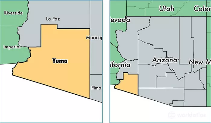
Yuma, Arizona, is a city rich in history and culture, strategically located in the southwestern corner of the United States. Understanding its position on a map provides insight into its significance and accessibility.
Yuma serves as the county seat of Yuma County and is recognized as the “Sunniest City on Earth,” enjoying abundant sunshine throughout the year. Its unique location has made it a pivotal point for transportation and commerce.
Yuma’s Location in Arizona
To find Yuma on a map, you’ll need to look at the southwestern corner of Arizona. Arizona is one of the four states in the U.S. that make up the “Four Corners” region, but Yuma is not near that area. Instead, it sits close to the borders of two other states: California and Mexico.
- State: Arizona
- County: Yuma County
- Region: Southwestern United States
Yuma is approximately 180 miles southwest of Phoenix, the capital of Arizona, and about 180 miles east of San Diego, California. Its location makes it a key city for trade, tourism, and transportation between the U.S. and Mexico.
Accessibility and Transportation
Yuma’s location makes it easily accessible by various modes of transportation:
- By Road: The city is connected by major highways, including Interstate 8 and U.S. Highway 95. It’s approximately a two-and-a-half-hour drive from San Diego, a three-hour drive from Phoenix, and five hours south of Las Vegas.
- By Rail: Amtrak’s Sunset Limited and Texas Eagle lines serve Yuma, providing passenger rail services to and from the city.
- By Air: Yuma International Airport offers multiple daily flights, primarily serviced by American Airlines, connecting the city to major hubs.
Yuma’s Surrounding Landmarks and Features
Yuma’s geography is not just about its coordinates; it’s also about the natural and man-made features that surround it. Here are some key landmarks:
- Colorado River: Yuma is located along the Colorado River, which provides water for agriculture and recreation. The river is a lifeline for the region.
- Imperial Sand Dunes: Just west of Yuma, in California, you’ll find the Imperial Sand Dunes, a popular spot for off-roading and outdoor activities.
- Kofa National Wildlife Refuge: To the east of Yuma, this refuge is home to diverse wildlife and stunning desert landscapes.
- Yuma Proving Ground: A U.S. Army facility located northeast of the city, known for its military testing and training.
Why Yuma’s Location Matters
Yuma’s location is not just a matter of geography; it has practical implications for its residents and visitors. Here’s why its location is significant:
- Agriculture: Yuma’s proximity to the Colorado River and its sunny climate make it an ideal location for farming. The city is known as the “Lettuce Capital of the World” and produces a significant portion of the U.S. winter vegetables.
- Tourism: Yuma’s location near major cities and its unique desert landscape attract tourists year-round. Popular activities include visiting historic sites, enjoying outdoor adventures, and exploring the nearby dunes.
- Trade and Transportation: Yuma’s position near the U.S.-Mexico border and major highways makes it a hub for trade and transportation.
Conclusion
Yuma’s distinctive position at the convergence of state, national, and international boundaries has shaped its history and continues to influence its role as a cultural and economic hub in the southwestern United States. Its accessibility and strategic location make it a noteworthy point on any map of the region.

