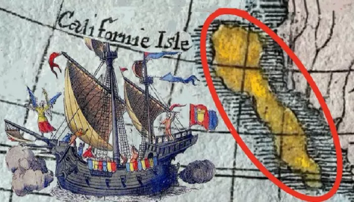
The depiction of California as an island on historical maps is one of the most intriguing cartographic misconceptions in American history. This error persisted for centuries, influencing exploration, settlement, and our understanding of the region’s geography. Exploring the origins and persistence of this myth offers valuable insights into early exploration, cultural influences, and the evolution of mapmaking.
Origins of the California Island Myth
The misconception that California was an island can be traced back to early European explorations and literary influences.
Literary Influence
In 1510, Spanish author Garci Rodríguez de Montalvo published “Las Sergas de Esplandián,” a chivalric romance that introduced the concept of California as a mythical island paradise. The novel described California as a remote island, rich in gold and precious stones, inhabited by beautiful Amazonian women. This fictional portrayal captured the imagination of explorers and mapmakers, embedding the idea of California as an island in popular consciousness.
Early Explorations and Misinterpretations
Spanish explorer Hernán Cortés, upon hearing tales of this mythical land, organized expeditions to locate it. In 1533, an expedition led by Diego de Becerra and Fortún Ximénez landed on the southern tip of the Baja California Peninsula. Observing the peninsula’s narrow width and surrounded by water, they concluded it was an island. This misinterpretation was documented and influenced subsequent cartographic representations.
Cartographic Evidence and the Spread of the Myth
The belief in California as an island was perpetuated through various maps and illustrations over the centuries.
Early Maps
The first known depiction of California as an island appeared in a 1541 drawing by Domingo del Castillo. This representation was influenced by earlier misconceptions and contributed to the spread of the island myth.
Prominent Cartographic Examples
Several renowned cartographers contributed to the perpetuation of the island myth:
- Michiel Colijn (1622): In his “Descriptio Indiae Occidentalis,” Colijn depicted California as an island, reinforcing the prevailing belief.
- Abraham Goos (1624): His maps continued the tradition of illustrating California as a separate landmass, influencing contemporary understanding.
- Henry Briggs (1625): Briggs’ maps further solidified the misconception, as they portrayed California detached from the mainland.
- John Speed (1627): Speed’s influential maps depicted California as an island, affecting both European and American perceptions.
Factors Contributing to the Persistence of the Myth
Several elements contributed to the enduring belief that California was an island:
Limited Exploration and Communication
The vast distances and technological limitations of the time hindered comprehensive exploration and accurate mapping. Reports from early explorers, combined with a lack of verification, allowed misconceptions to persist.
Influence of Popular Literature
The romanticized depiction of California in literature, such as Montalvo’s novel, captivated the imaginations of explorers and the public. This cultural influence reinforced the island narrative, making it a widely accepted belief.
Cartographic Tradition and Authority
Once established, the depiction of California as an island became a standard in mapmaking. Mapmakers often relied on previous works for reference, perpetuating errors. The authority of renowned cartographers lent credibility to these representations, making them difficult to correct.
Correction of the Misconception
The realization that California was part of the mainland rather than an island emerged gradually through exploration and evidence collection.
Explorations Providing Evidence
- Sebastián Vizcaíno (1602): His voyage along the California coast provided detailed observations, suggesting a connection to the mainland. However, his accounts were misinterpreted, and the island depiction persisted.
- Jesuit Missions (1706): Jesuit explorers like Eusebio Kino conducted extensive missions, collecting evidence that California was a peninsula. Their findings began to challenge the island narrative.
Official Recognition
In 1747, King Ferdinand VI of Spain issued a decree stating that California was not an island. This official recognition was based on accumulating evidence from explorers and missionaries. Despite this, the island depiction continued on some maps for years.
Legacy and Significance
The California island myth highlights the interplay between exploration, cultural influence, and cartography. It underscores how narratives and beliefs can shape our understanding of geography, even in the face of contradicting evidence. This episode serves as a reminder of the importance of critical examination and verification in the pursuit of knowledge.
Conclusion
The depiction of California as an island is a testament to the complexities of early exploration and mapmaking. While the myth has long been debunked, its persistence in historical maps offers valuable insights into the processes of knowledge formation and dissemination. Understanding this history enriches our appreciation of California’s true geographical identity and the evolution of our collective understanding.

