Montana, known as “Big Sky Country,” is a state in the northwestern United States. It is renowned for its vast landscapes, diverse terrain, and rich history. Understanding the geographical distribution of its cities provides insight into the state’s cultural and economic fabric. This article offers a detailed overview of Montana’s major cities, their locations, and their significance, complemented by maps for better visualization.
What is Montana’s Geography
Montana is the fourth-largest state in the U.S., covering an area of 147,040 square miles (381,154 km²), making it larger than countries like Japan and Germany. It shares its northern border with the Canadian provinces of British Columbia, Alberta, and Saskatchewan. To the east, it borders North Dakota and South Dakota; to the south, Wyoming; and to the west and southwest, Idaho. The state’s diverse topography includes the Rocky Mountains in the west and expansive plains in the east. This varied landscape influences the distribution and development of its cities.
Major Cities in Montana
Montana’s cities are as diverse as its landscapes, each offering unique cultural, economic, and recreational opportunities. Below is an overview of the major cities, accompanied by maps to illustrate their locations.
Billings
Billings is the largest city in Montana, serving as a significant trade and distribution center. Its economy is bolstered by sectors such as energy, agriculture, and healthcare. The city offers a blend of urban amenities and access to outdoor activities, making it a vibrant community.
Missoula
Missoula is known for its vibrant arts scene and as the home of the University of Montana. The city’s economy benefits from education, healthcare, and retail sectors. Surrounded by mountains and rivers, Missoula is a hub for outdoor enthusiasts.
Great Falls
Great Falls, located along the Missouri River, is known for its rich history and cultural attractions. The city has a strong military presence due to the nearby Malmstrom Air Force Base. Great Falls also serves as a regional center for healthcare and education.
Bozeman
Bozeman is one of Montana’s fastest-growing cities, known for its high quality of life and outdoor recreational opportunities. It is home to Montana State University, contributing to a vibrant educational and cultural scene. The city’s economy is diverse, with strengths in technology, tourism, and agriculture.
Helena
Helena is the capital city of Montana, rich in history and architectural heritage. As the state capital, it is the center of government activities. The city’s economy is supported by government services, healthcare, and tourism, with numerous historical sites and outdoor activities available.
Butte
Butte has a rich mining history and is known for its preserved historical district. The city played a significant role in the early 20th-century mining boom and retains much of its historical architecture. Today, Butte celebrates its heritage through various festivals and museums.
Kalispell
Kalispell is the gateway to Glacier National Park, offering stunning natural beauty and outdoor recreational opportunities. The city’s economy is driven by tourism, healthcare, and manufacturing. Its proximity to Flathead Lake and ski resorts makes it a year-round destination.
Havre
Havre is a regional center for agriculture and education in north-central Montana. The city is home to Montana State University-Northern and serves as a hub for the surrounding rural communities. Havre’s history is showcased in its museums and historical sites.
Map of Montana’s Major Cities
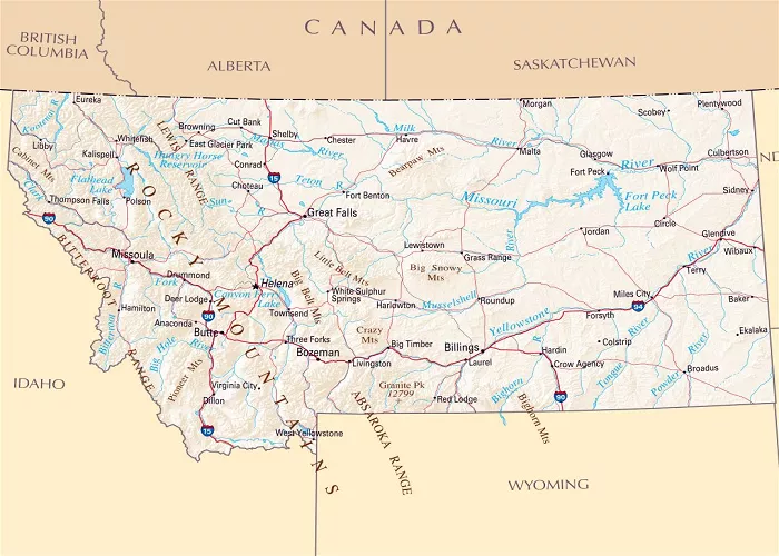
Below is a map highlighting Montana’s major cities, providing a visual reference to their locations within the state.
This map illustrates the geographical distribution of Montana’s major cities, aiding in understanding their relative locations and the state’s layout.
Transportation and Accessibility
Montana’s major cities are connected through an extensive network of highways and interstates, facilitating travel and commerce across the state.
Interstate Highways
- Interstate 15 (I-15): Runs north-south through the western part of the state, connecting cities like Butte and Helena.
- Interstate 90 (I-90): Traverses east-west, linking cities such as Billings, Bozeman, and Missoula.
- Interstate 94 (I-94): Branches off from I-90 near Billings, extending eastward towards North Dakota.
These interstates are vital for the movement of goods and people, supporting Montana’s economy and accessibility.
Conclusion
Montana’s major cities each contribute uniquely to the state’s identity, offering a blend of cultural, economic, and recreational opportunities. From the bustling trade center of Billings to the historical charm of Helena and the outdoor paradise of Missoula, Montana’s urban centers provide diverse experiences for residents and visitors alike. Understanding the geography and characteristics of these cities enhances one’s appreciation of Montana’s rich heritage and dynamic communities.

