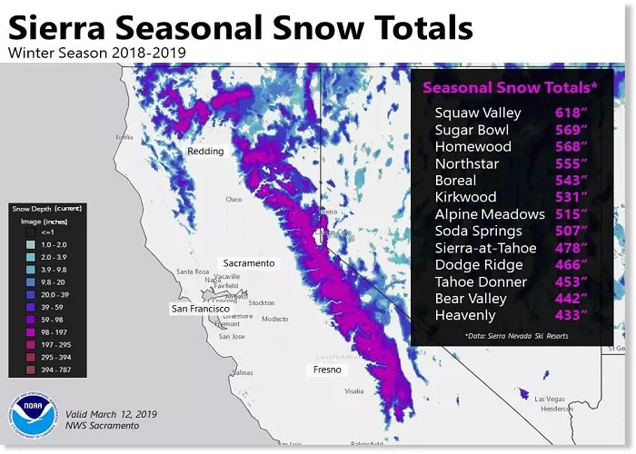
Nevada, known for its vast deserts and the Sierra Nevada mountain range, experiences significant snowfall, especially in its mountainous regions. Understanding the distribution and depth of snow across the state is essential for various sectors, including water resource management, agriculture, transportation, and tourism. This article provides a comprehensive overview of Nevada’s snow patterns, utilizing current snow depth maps and analyses to offer readers a clear understanding of the state’s snow distribution.
Importance of Snow Mapping in Nevada
Snow mapping plays a crucial role in monitoring water resources, forecasting weather conditions, and ensuring safe travel across the state. Snowpacks in Nevada’s mountains serve as natural reservoirs, releasing water slowly into rivers and reservoirs, which is vital for irrigation and municipal water supplies. Accurate snow maps assist in predicting water runoff, managing flood risks, and planning for drought conditions. Additionally, these maps are invaluable for winter sports enthusiasts and travelers, providing up-to-date information on snow conditions and road statuses.
Sources of Snow Data in Nevada
Several organizations and agencies collect and disseminate snow data in Nevada:
- National Operational Hydrologic Remote Sensing Center (NOHRSC): Provides national snow analyses, including snow depth and snow water equivalent maps.
- California Nevada River Forecast Center (CNRFC): Offers snowpack and precipitation data for Nevada, aiding in hydrological forecasting.
- Nevada SNOTEL Network: Operated by the USDA Natural Resources Conservation Service, this network provides real-time snow and precipitation data from various monitoring sites across Nevada.
- Nevada Department of Transportation (NDOT): Provides road condition updates, including information on snow and ice, to ensure traveler safety.
Current Snow Depth in Nevada
As of March 7, 2025, snow depth across Nevada varies significantly, with the Sierra Nevada mountains receiving substantial snowfall, while the western and southern regions experience lighter snow cover. The Sierra Nevada range, along Nevada’s western border, typically accumulates the most snow, with depths reaching up to several feet in higher elevations. In contrast, the southern regions, including areas near Las Vegas, may have minimal to no snow cover during this time.
For the most accurate and current snow depth information, refer to the following resources:
- National Snow Analyses: Provides daily-updated maps of snow depth across the U.S., including Nevada.
- CNRFC Snow Page: Offers detailed snowpack and precipitation data specific to the California-Nevada region.
- Nevada SNOTEL Report: Delivers real-time snow and precipitation data from monitoring sites throughout Nevada.
Snow Cover and Water Resource Implications
The distribution and depth of snow in Nevada have direct implications for the state’s water resources:
- Snowmelt Runoff: As temperatures rise, snowmelt contributes to river flows, replenishing reservoirs and aquifers essential for irrigation and municipal water supplies.
- Drought Monitoring: Snow maps help identify areas with below-average snowpack, aiding in early detection of drought conditions and facilitating water conservation measures.
- Flood Forecasting: Understanding snow depth and water equivalent data assists in predicting potential flooding events during rapid snowmelt periods.
Snow Data for Tourism and Recreation
For tourists and recreational enthusiasts, snow maps provide valuable information:
- Ski Resorts: Current snow depth and conditions are crucial for planning visits to ski resorts in the Sierra Nevada and other mountainous regions.
- Travel Planning: Up-to-date snow and road condition maps assist travelers in planning safe routes, especially during winter months.
Climate Change and Snow Patterns
Recent studies indicate shifts in snow patterns in Nevada due to climate change:
- Reduced Snowfall: Some regions have experienced a decline in snowfall amounts, impacting water availability.
- Earlier Snowmelt: Warmer temperatures have led to earlier snowmelt, affecting water storage and agricultural planning.
Monitoring these changes through snow mapping is essential for adapting water management strategies and preparing for future climatic conditions.
Conclusion
Snow maps are indispensable tools for understanding and managing Nevada’s complex snow patterns. They provide critical information for water resource management, tourism, transportation, and climate studies. By utilizing data from reputable sources such as NOHRSC, CNRFC, and the Nevada SNOTEL Network, stakeholders can make informed decisions to address the challenges and opportunities presented by Nevada’s snow cover.
For the most current and detailed snow maps, refer to the resources mentioned above, and always consider consulting local authorities or experts when planning activities affected by snow conditions.

