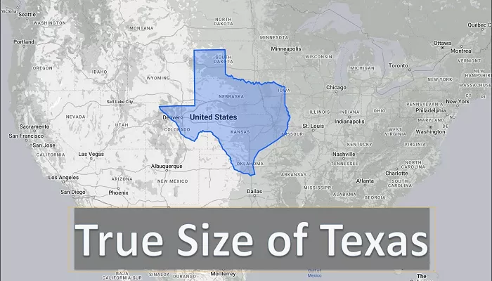
Texas, often referred to as the “Lone Star State,” is renowned for its vast landscapes, diverse terrain, and significant role in the United States’ economy, history, and culture. As the second-largest state in the U.S., Texas stands out not only for its sheer size but also for the variety of geographical features and industries that thrive within its borders.
The state’s expansive area has played a crucial role in shaping its economic opportunities, infrastructure development, and cultural identity. Understanding the scale of Texas compared to other states and nations highlights its geographical prominence and the diversity found within its climate, population, and industries.
Texas’s Physical Dimensions and Comparisons
Total Land Area
- Texas covers approximately 268,596 square miles (695,662 square kilometers), making it the second-largest state in the U.S. after Alaska.
- The state’s vastness encompasses multiple climate zones, ecosystems, and economic sectors, creating a unique blend of geography and culture.
Comparing Texas to Other U.S. States
- Alaska: While Texas is enormous, Alaska remains the largest U.S. state, covering about 665,384 square miles, making it approximately 2.47 times the size of Texas.
- California: As the third-largest U.S. state, California spans roughly 163,696 square miles, making Texas about 61% larger.
- Rhode Island: Texas dwarfs the smallest state, Rhode Island (1,214 square miles), and could fit more than 200 Rhode Islands within its borders.
- Other States: Texas is larger than the combined areas of 15 of the smallest U.S. states, further emphasizing its massive scale.
Comparing Texas to Countries Around the World
- If Texas were a country, it would be the 40th largest nation globally, surpassing countries like France (248,573 square miles), Germany (137,988 square miles), and the United Kingdom (93,628 square miles) in total land area.
- The land area of Texas is comparable to that of Ukraine and is significantly larger than South Korea, Japan, or Italy.
The Impact of Texas’s Size on Infrastructure and Economy
Due to its vast area, Texas has had to develop extensive infrastructure to connect its various regions. This has influenced everything from transportation networks to economic development, ensuring efficient movement of goods, services, and people.
Transportation Infrastructure
- Highways: Texas has the largest highway system in the U.S., with more than 683,000 miles of roadways, including major interstate routes such as I-10, I-35, and I-45.
- Railroads: A vast railway network helps transport goods across the state, particularly from ports along the Gulf of Mexico to cities inland.
- Airports: Texas is home to two of the busiest airports in the country—Dallas/Fort Worth International Airport (DFW) and George Bush Intercontinental Airport (IAH) in Houston—facilitating national and international travel.
- Ports: The Port of Houston is one of the largest and busiest ports in the U.S., playing a key role in global trade.
Economic Diversity and Regional Strengths
The size of Texas allows for diverse economic activities, each concentrated in different regions:
- Energy Industry: The oil-rich regions of West Texas and the Permian Basin have helped Texas become a global leader in oil and gas production.
- Technology and Innovation: The Dallas-Fort Worth and Austin areas have emerged as major technology hubs, attracting major corporations and startups.
- Agriculture and Ranching: Texas leads the nation in cattle production, and its vast agricultural lands contribute to cotton, wheat, and citrus farming.
- Manufacturing and Trade: The proximity to Mexico has fostered a strong manufacturing and logistics sector, with Texas serving as a key trade hub between the U.S., Mexico, and Latin America.
Geographical Diversity Within Texas
Texas’s immense size contributes to its varied geography, which includes mountains, deserts, forests, and coastal plains.
Key Geographical Regions
- The Gulf Coast – Features humid coastal plains, marshlands, and major ports. Cities like Houston, Galveston, and Corpus Christi thrive in this region.
- The Hill Country – Located in central Texas, this region is known for its rolling hills, limestone cliffs, and scenic rivers. The cities of Austin and San Antonio lie within this area.
- West Texas and the Desert Region – This area features arid deserts and rugged mountains, including the famous Big Bend National Park.
- The Great Plains – Covering much of northern Texas, this region includes vast grasslands that support Texas’s strong agriculture and cattle ranching industries.
- The Piney Woods – Found in East Texas, this heavily forested region is home to dense pine forests, rivers, and wetlands.
Conclusion
Texas’s massive size plays a defining role in its economy, culture, geography, and national influence. As the second-largest state in the U.S., it surpasses many countries in land area and encompasses a variety of landscapes and industries.
Its vast infrastructure, thriving cities, and regional economic strengths make Texas a critical player in national and global markets. Whether through its oil production, technology innovation, agriculture, or trade connections, Texas remains a powerful force in shaping the future of the United States.
Understanding its sheer size and impact helps to appreciate why Texas is often regarded as a state unlike any other—rich in history, opportunity, and resilience.

