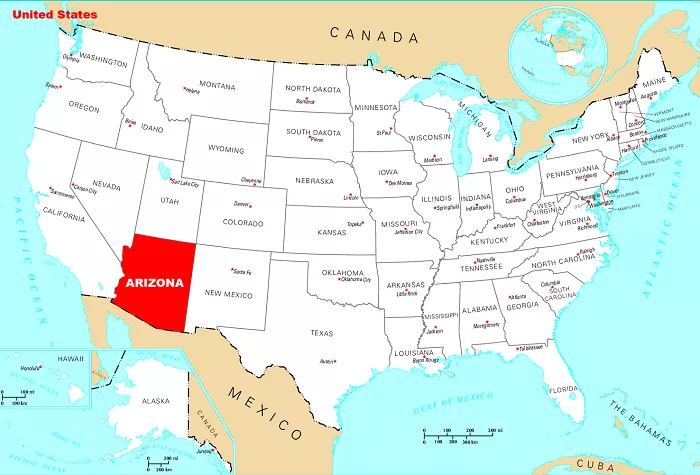
Arizona, often referred to as “The Grand Canyon State,” is located in the southwestern region of the United States. It is the sixth-largest state in terms of area and the 14th most populous, known for its stunning landscapes, rich history, and diverse ecosystems. Understanding its location on a U.S. map requires examining its borders, neighboring states, geographical features, climate, and major cities.
Neighboring States and Borders
Arizona shares borders with four U.S. states and one country:
Utah: Located directly to the north, Utah shares a long border with Arizona. The state is known for its vast desert landscapes and national parks.
Colorado: Found at the northeastern tip of Arizona, where the two states meet at the famous Four Corners region. This is the only point in the United States where four states—Arizona, Colorado, New Mexico, and Utah—intersect.
New Mexico: Situated to the east, New Mexico and Arizona share a long border that stretches from the Four Corners down to the U.S.-Mexico border.
California: To the west, Arizona borders California, separated in part by the Colorado River. The river serves as a natural boundary and plays a crucial role in Arizona’s water supply.
Nevada: Also to the west, Arizona shares a border with Nevada. The Hoover Dam, which straddles the Arizona-Nevada border, is one of the most important engineering marvels in the country, providing hydroelectric power and water storage for multiple states.
Mexico: Arizona shares an international border with Sonora, Mexico, stretching for approximately 389 miles (626 km). This border plays a significant role in trade, culture, and migration between the U.S. and Mexico.
The Four Corners Monument
One of Arizona’s most unique geographical features is the Four Corners Monument, where Arizona, Colorado, Utah, and New Mexico meet at a single point. This is the only location in the U.S. where four states intersect, making it a popular tourist attraction.
Geographical Features
Arizona’s landscape is one of the most diverse in the country, featuring deserts, mountains, forests, and canyons. The state is divided into three main regions:
1. The Colorado Plateau (Northern Arizona)
This region is characterized by high-elevation plateaus, deep canyons, and forested areas. Some key features include:
The Grand Canyon: One of the world’s most famous natural wonders, the Grand Canyon was carved over millions of years by the Colorado River. It stretches for 277 miles (446 km) and attracts millions of visitors annually.
The Painted Desert: Known for its striking multicolored rock formations, this area offers breathtaking scenery.
Petrified Forest National Park: Home to one of the largest collections of petrified wood in the world, this park preserves fossilized trees that date back over 200 million years.
San Francisco Peaks: The tallest mountains in Arizona, with Humphreys Peak standing at 12,637 feet (3,852 meters).
2. The Central Highlands
This transitional region between the high plateaus of northern Arizona and the low deserts of the south contains rugged mountains and dense forests. Key features include:
Mogollon Rim: A steep escarpment that runs diagonally across the state, marking the southern edge of the Colorado Plateau.
Prescott National Forest: A vast forested area with pine-covered mountains, making it a popular destination for outdoor enthusiasts.
Verde River: One of Arizona’s few free-flowing rivers, providing a critical water source and habitat for wildlife.
3. The Sonoran Desert (Southern Arizona)
The Sonoran Desert dominates the southern part of Arizona and is one of the most biologically diverse deserts in the world. Features include:
Saguaro National Park: Named after the giant saguaro cactus, which can grow over 40 feet tall and live for more than 150 years.
Organ Pipe Cactus National Monument: A UNESCO Biosphere Reserve that protects the rare organ pipe cactus and other desert wildlife.
The Salt River Valley: A major agricultural and metropolitan area that includes Phoenix and its surrounding cities.
Climate
Arizona experiences a wide range of climates due to its diverse topography:
Desert Climate (Low Elevations): The southern part of the state, including Phoenix and Tucson, has an arid desert climate with extremely hot summers, where temperatures often exceed 110°F (43°C). Winters are mild, making it a popular destination for tourists and retirees.
Semi-Arid and Mediterranean Climate (Central Highlands): Cities such as Prescott and Sedona experience a mix of warm summers and cool winters with occasional snowfall.
Alpine Climate (Northern Arizona): The higher elevations, including Flagstaff and the San Francisco Peaks, experience cold winters with heavy snowfall, making them popular locations for skiing and winter sports.
Major Cities and Economic Hubs
Arizona is home to several major cities that contribute to its economy and culture:
Phoenix (State Capital): The largest city in Arizona and the fifth-most populous city in the U.S. It serves as a major hub for business, technology, and education.
Tucson: Home to the University of Arizona, Tucson is known for its vibrant arts scene and desert landscapes.
Mesa: The third-largest city in the state, Mesa has a strong economy and is known for its thriving aerospace and technology industries.
Chandler: A fast-growing city with a strong focus on technology and innovation.
Scottsdale: Known for its upscale resorts, golf courses, and luxury lifestyle.
Economic Overview
Arizona has a diverse economy that includes:
Tourism: The Grand Canyon, Sedona, and other natural attractions bring millions of visitors each year.
Technology: Arizona has a growing tech sector, with companies like Intel and semiconductor manufacturers investing in the state.
Agriculture: Cotton, citrus, and cattle are among the key agricultural products.
Aerospace and Defense: Arizona is home to major defense contractors and military bases, contributing significantly to the state’s economy.
Conclusion
On a U.S. map, Arizona is positioned in the southwestern region, bordered by Utah, Colorado, New Mexico, Nevada, California, and Mexico. Its diverse geography, ranging from deserts to mountains, and its strategic location make it a unique and integral part of the United States. The state is renowned for its natural beauty, rich cultural heritage, and economic importance, making it a fascinating place to explore and understand.

