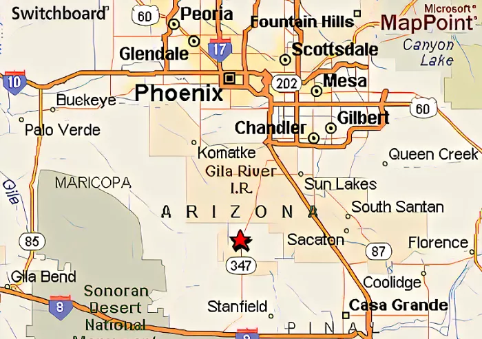
Maricopa, Arizona, is a rapidly growing city located in the southwestern United States. Known for its rich history, diverse community, and strategic location, Maricopa has become an important hub in the state of Arizona. This article provides a comprehensive overview of Maricopa’s location, geography, history, demographics, infrastructure, and more.
Geographical Location
Coordinates and Position
Maricopa is situated at approximately 33.0567° N latitude and 112.0467° W longitude. It lies in the Gila River Valley within Pinal County, Arizona.
Proximity to Major Cities
- Phoenix: Maricopa is about 35 miles south of Phoenix, the state capital.
- Tucson: Approximately 100 miles northwest of Tucson.
- Casa Grande: Roughly 20 miles northwest of Casa Grande.
Surrounding Features
The city is bordered by the Ak-Chin Indian Community to the south and the Gila River Indian Community to the north. The terrain is predominantly flat desert, with mountain ranges such as the South Mountains and the Sierra Estrella nearby.
Historical Background
Early Settlement
Maricopa’s origins trace back to the mid-19th century with the establishment of Maricopa Wells, a vital watering stop for travelers and mail routes like the Butterfield Overland Mail.
Development and Incorporation
The city underwent several relocations before settling in its current location in the 1880s to align with railroad developments. Maricopa was officially incorporated as a city in 2003.
Demographics
Population Growth
As of 2022, Maricopa’s population is approximately 66,290, making it the largest incorporated municipality in Pinal County. The city has experienced significant growth since the early 2000s.
Diversity
Maricopa boasts a diverse population, with a mix of ethnicities and cultures contributing to the city’s vibrant community.
Infrastructure and Transportation
Roadways
- State Route 347: Also known as John Wayne Parkway, it connects Maricopa to Interstate 10 and Phoenix.
- State Route 238: Links Maricopa to Gila Bend and other western regions.
Rail Services
Maricopa Station serves as a stop for Amtrak’s Sunset Limited and Texas Eagle routes, providing rail connections to major cities like Los Angeles and Chicago. Additionally, Amtrak Thruway Motorcoach offers bus services to Phoenix.
Public Transit
The city operates the Maricopa Express Transit (MET) system, offering local bus services.
Economy and Employment
Economic Drivers
Maricopa’s economy is supported by various sectors, including retail, education, healthcare, and agriculture. The nearby Ak-Chin Indian Community contributes through enterprises like Harrah’s Ak-Chin Casino and related businesses.
Employment Opportunities
The city’s growth has led to increased job opportunities, attracting professionals and families seeking employment in the region.
Education
Schools
Maricopa Unified School District oversees public education in the city, comprising elementary, middle, and high schools.
Higher Education
While Maricopa does not host a university, residents have access to nearby institutions such as Central Arizona College and Arizona State University campuses in the Phoenix metropolitan area.
Recreation and Culture
Parks and Trails
Maricopa offers several parks and recreational facilities, promoting outdoor activities and community engagement. The city’s proximity to natural attractions like the South Mountains provides additional opportunities for hiking and exploration.
Community Events
The city hosts various events throughout the year, fostering a sense of community and celebrating cultural diversity.
Conclusion
Maricopa, Arizona, is a dynamic city that blends historical significance with modern growth. Its strategic location near major urban centers, coupled with a strong sense of community and ongoing development, makes it an attractive place to live, work, and visit. Understanding Maricopa’s place on the map provides insight into its role within Arizona’s landscape and its potential for future growth.

