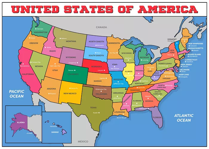
The question of whether the United States has 50 or 52 states is a common source of confusion. While the correct answer is 50, the misconception persists due to historical, cultural, and territorial complexities. This article explores the origins of the confusion, the official count of U.S. states, and how territories like Puerto Rico and Washington, D.C., contribute to the debate. We’ll also examine the geographical, political, economic, and cultural factors that shape America’s statehood structure.
The Official Count: Why the U.S. Has 50 States
Historical Expansion of the United States
- The U.S. began with 13 original colonies (1776).
- Through treaties, purchases, and annexations, it grew to 50 states by 1959.
- Hawaii (1959) was the last state admitted.
Why People Think There Are 52 States
- Misinterpretation of territories: Some include Puerto Rico and Washington, D.C.
- Confusion with stars on old flags: The flag had 48 stars (1912–1959), not 52.
- Cultural references: Movies, songs, and jokes sometimes exaggerate the number.
List of All 50 States
| Region | Number of States | Examples |
|---|---|---|
| Northeast | 9 | New York, Massachusetts |
| Midwest | 12 | Illinois, Ohio |
| South | 16 | Texas, Florida |
| West | 13 | California, Alaska |
U.S. Territories: The Source of Confusion
Major U.S. Territories
| Territory | Status | Population |
|---|---|---|
| Puerto Rico | Unincorporated | 3.2 million |
| Washington, D.C. | Federal District | 700,000 |
| Guam | Unincorporated | 170,000 |
| U.S. Virgin Islands | Organized | 100,000 |
Why Territories Are Not States
- No voting representation in Congress.
- Limited self-governance.
- Cannot vote in presidential elections (except D.C. since 1961).
Could They Become States?
- Puerto Rico: Voted for statehood in 2020, but Congress must approve.
- Washington, D.C.: Pushed for statehood as “Washington, Douglass Commonwealth.”
Geographical & Political Differences Between States and Territories
State vs. Territory Comparison
| Feature | State | Territory |
|---|---|---|
| Federal Taxes | Yes | Partial (Puerto Rico exempt) |
| Voting Rights | Full | Limited |
| Senators | 2 | 0 |
How State Borders Were Determined
- Natural boundaries (Mississippi River, Rocky Mountains).
- Historical treaties (Louisiana Purchase, Mexican Cession).
- Congressional decisions (Civil War compromises).
Cultural & Economic Impact of Statehood
Why Statehood Matters
- More federal funding for education and infrastructure.
- Greater political influence (electoral votes, senators).
- Economic benefits (business incentives, trade policies).
Case Study: Alaska & Hawaii (1959)
- Alaska: Gained military and oil industry advantages.
- Hawaii: Boosted tourism and Pacific trade.
If Puerto Rico Became a State
- Would be the 29th largest by population.
- Could shift political power toward Democrats.
Ecological & Environmental Considerations
State vs. Territory Land Use
- States: More protected national parks (Yellowstone, Grand Canyon).
- Territories: Vulnerable to climate change (hurricanes in Puerto Rico).
How Statehood Affects Environmental Policies
- States set their own pollution laws.
- Territories rely on federal regulations.
Common Myths Debunked
1. The U.S. Flag Once Had 52 Stars
- Fact: The flag never had 52 stars. It went from 48 → 49 (Alaska) → 50 (Hawaii).
2. Puerto Rico and D.C. Are Already States
- Fact: They have limited self-rule but lack full state rights.
3. There Are Secret U.S. States
- Fact: No hidden states—just creative internet rumors.
Conclusion
The United States officially consists of 50 states, not 52. However, territories like Puerto Rico and Washington, D.C., contribute to the confusion. While they may become states in the future, they currently lack full representation. Understanding the difference helps clarify America’s political and geographical structure.

