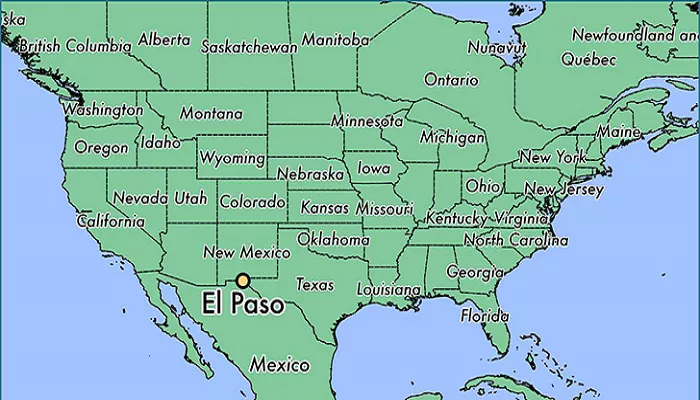
El Paso, often referred to as “The Sun City,” is a city rich in history and culture, located in the westernmost tip of Texas. Understanding its geographical position provides insight into its unique development and significance.El Paso stands as the sixth-most populous city in Texas and the 22nd in the United States. Founded in 1848, it has evolved from a military post to a thriving urban center. Its strategic location has played a pivotal role in shaping its history, economy, and cultural identity.
Where Is El Paso Located in Texas?
El Paso is in the westernmost corner of Texas, right on the border with Mexico. Here’s how it compares to other major Texas cities:
- 680 miles (1,100 km) west of Dallas
- 550 miles (890 km) west of San Antonio
- 270 miles (430 km) southeast of Phoenix, Arizona
- Just across the Rio Grande from Ciudad Juárez, Mexico
El Paso is the sixth-largest city in Texas and sits in El Paso County.
El Paso’s Coordinates (Exact Location on the Map)
- Latitude: 31.7619° N
- Longitude: 106.4850° W
This places El Paso in the Mountain Time Zone (MT)—unlike most of Texas, which is in the Central Time Zone.
El Paso’s Surrounding Cities and Regions
El Paso is isolated from other big Texas cities but close to major Southwestern destinations:
Major Nearby U.S. Cities
- Las Cruces, New Mexico (42 miles northwest) – Home of New Mexico State University.
- Albuquerque, New Mexico (270 miles north) – New Mexico’s largest city.
- Phoenix, Arizona (270 miles west) – A major Southwestern hub.
Mexican Border Cities
- Ciudad Juárez, Chihuahua (right across the Rio Grande) – One of Mexico’s largest cities.
Smaller Nearby Towns
- Socorro, Texas (15 miles southeast) – A historic farming community.
- Anthony, Texas/New Mexico (20 miles north) – A small town split between two states.
Historical Significance of Location
The city’s establishment along the Rio Grande has been crucial since its founding. The river not only provided essential water resources but also served as a vital transportation route. This strategic advantage facilitated trade and communication, fostering economic development and cultural exchange. The presence of Fort Bliss, established in 1848, further underscores the area’s historical military significance.
Economic Importance
El Paso’s proximity to the U.S.-Mexico border enhances its role in international trade. Major highways such as Interstate 10 and Interstate 25 converge in the city, linking it to national and international markets. This accessibility supports a robust economy, with key sectors including manufacturing, healthcare, tourism, and military. The presence of Fort Bliss, one of the largest military complexes in the U.S., contributes significantly to the local economy.
Cultural Influence
The city’s location has fostered a unique blend of cultures, prominently featuring Hispanic influences. This cultural richness is evident in its architecture, festivals, cuisine, and traditions, making El Paso a vibrant and diverse urban center. The annual Sun Bowl, a college football postseason game, highlights the city’s cultural significance. Additionally, the proximity to Mexico has fostered a bicultural environment, influencing music, art, and daily life.
Conclusion
El Paso’s geographical position in western Texas has been instrumental in shaping its history, economy, and cultural identity. Its strategic location continues to influence its role as a dynamic and influential city within the state and the nation. Understanding this location provides a lens through which to appreciate the city’s unique character and ongoing development.

