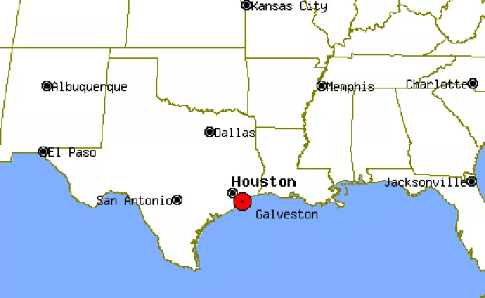
Galveston is a coastal city in southeastern Texas, renowned for its rich history, vibrant culture, and scenic beaches. Situated on Galveston Island and Pelican Island, it serves as the county seat of Galveston County. Understanding its precise location on a Texas map can enhance your appreciation of its unique geography and significance.
Galveston’s Location on a Texas Map
Galveston is located in southeastern Texas, along the Gulf of Mexico. Here’s how to find it on a map:
Region: Gulf Coast
County: Galveston County
Coordinates: 29.3013° N, 94.7977° W
Distance from Major Cities:
- About 50 miles southeast of Houston
- About 190 miles southwest of New Orleans
- About 300 miles east of San Antonio
How to Spot Galveston on a Texas Map
- Look for the Gulf of Mexico along Texas’s southeastern coast.
- Find Houston—Galveston is just southeast of it.
- Locate Galveston Island, a barrier island where the city sits.
- Identify Galveston Bay, which separates the island from the mainland.
Galveston’s Geography and Surroundings
Galveston Island
Galveston is primarily located on Galveston Island, a long, narrow barrier island:
- Length: About 27 miles
- Width: Ranges from 1.5 to 3 miles
- Features: Beaches, historic districts, and the Galveston Seawall (a protective barrier against hurricanes).
Nearby Bodies of Water
- Gulf of Mexico: Borders the island’s southern side.
- Galveston Bay: Lies to the north, separating the island from mainland Texas.
- Bolenae Bayou & Offatts Bayou: Smaller waterways within the city.
Key Landmarks to Help Locate Galveston
- The Strand Historic District (downtown Galveston)
- Moody Gardens (a popular tourist attraction)
- Schlitterbahn Waterpark
- Galveston Port (one of the busiest cruise and shipping ports in Texas)
Transportation to Galveston
Accessing Galveston is facilitated by several key routes:
- Interstate 45 (I-45): This major highway runs south from Dallas through Houston and continues directly to Galveston, making the city easily accessible by car.
- State Highways: Various state routes connect Galveston to nearby regions, supporting both local and tourist traffic.
Utilizing Maps for Navigation
For detailed navigation and exploration, consider the following resources:
- Galveston Discovery Map: This free multimedia island map offers insights into local businesses and attractions, enhancing your visit.
- City of Galveston’s Official GIS Website: Provides detailed maps and geographic information systems data for in-depth exploration.
Conclusion
Galveston’s strategic location along the Gulf Coast of Texas makes it a prominent destination for both residents and visitors. By understanding its position on a Texas map, you can better appreciate its accessibility, cultural significance, and the natural beauty it offers.

