Sedona, Arizona, is a city renowned for its stunning red sandstone formations and vibrant arts scene. Located in the northern Verde Valley region, it spans the county line between Coconino and Yavapai counties. As of the 2010 census, the population was 10,031.
Geographical Location
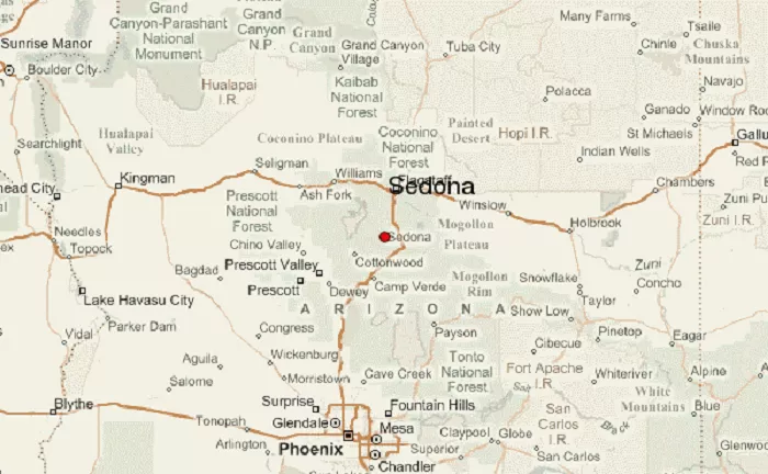
Sedona is situated in north-central Arizona. It lies approximately 30 miles south of Flagstaff and 115 miles north of Phoenix. The city is nestled within the Coconino National Forest, surrounded by the picturesque red rock formations that have become its hallmark.
Sedona’s Geographic Features
Sedona sits in the Mogollon Rim region, a dramatic escarpment that marks the edge of the Colorado Plateau. The city is surrounded by:
- Red Rock Country – Famous sandstone formations like Cathedral Rock, Bell Rock, and Snoopy Rock.
- Oak Creek – A year-round stream that flows through the city, creating lush greenery.
- Coconino National Forest – A vast forested area with hiking trails and wildlife.
Climate in Sedona
Sedona has a semi-arid climate with:
- Mild winters (average highs in the 50s°F / 10-15°C)
- Hot summers (often above 90°F / 32°C, but dry)
- Monsoon season (July-September brings brief thunderstorms)
The elevation of 4,350 feet (1,326 meters) keeps temperatures cooler than Phoenix.
Accessibility
Sedona is accessible via several major highways:
- Interstate 17 (I-17): This highway connects Phoenix to Flagstaff. Travelers can exit onto State Route 179 (SR 179) to reach Sedona.
- State Route 89A (SR 89A): This route runs through Sedona, connecting the city to Jerome and Cottonwood to the west, and to Oak Creek Canyon and Flagstaff to the east.
For detailed maps and parking information, visitors can refer to resources provided by the City of Sedona.
Nearby Attractions
Sedona’s central location makes it an ideal base for exploring northern Arizona:
- Grand Canyon National Park: Located about 2.5 hours north of Sedona, the Grand Canyon offers breathtaking vistas and numerous hiking opportunities.
- Monument Valley Navajo Tribal Park: Approximately a 3-hour drive northeast, this park features iconic red sandstone buttes and mesas.
- Petrified Forest National Park: About 2 hours east, this park is known for its fossilized trees and colorful landscapes.
Why Is Sedona Important?
Sedona is more than just a beautiful desert town—it’s a major tourist destination and spiritual retreat.
1. Tourism & Outdoor Adventures
- Hiking & Biking – Trails like Devil’s Bridge and Cathedral Rock attract outdoor lovers.
- Jeep Tours – Explore rugged terrain on off-road adventures.
- Vortex Sites – Believed to have spiritual energy, drawing healers and meditators.
2. Arts & Culture
- Tlaquepaque Arts Village – A Mexican-style shopping district with galleries.
- Sedona International Film Festival – A major cultural event.
3. Gateway to Northern Arizona Attractions
- Grand Canyon (2 hours away)
- Montezuma Castle National Monument (45 minutes away)
- Jerome Ghost Town (1 hour away)
Conclusion
Sedona, Arizona, is a stunning desert city surrounded by red rock formations, deep canyons, and lush forests. Located just two hours north of Phoenix, it’s a perfect getaway for nature lovers, adventurers, and spiritual seekers.
Now that you know where Sedona is on the map, you can plan your visit or simply appreciate its beauty from afar. Whether you’re hiking its famous trails or exploring its arts scene, Sedona is truly one of Arizona’s most magical places.

