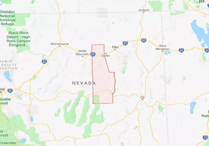
Eureka County, located in north-central Nevada, is a region rich in history and natural beauty. Understanding its geography is essential for residents, visitors, and those interested in the state’s development. This article offers a comprehensive overview of Eureka County’s location, history, demographics, and resources for accessing detailed maps.
A detailed map of Eureka County serves as a valuable tool for navigating its diverse landscapes, understanding its historical sites, and appreciating its unique position within Nevada. Whether you’re planning a visit, considering relocation, or simply curious about the area, this guide provides essential information to enhance your understanding of Eureka County.
Geographical Location and Boundaries
Eureka County is situated in the heart of Nevada, bordered by several counties:
- North: Elko County
- East: White Pine County
- South: Nye County
- West: Lander County
The county encompasses an area of approximately 4,180 square miles, with 4,176 square miles being land and 4.3 square miles covered by water, accounting for 0.1% of its total area. The county’s highest point is Diamond Peak, reaching an elevation of 10,631 feet in the Diamond Mountains along the border with White Pine County.
County Seat and Major Communities
The county seat is Eureka, a historic town founded in the late 19th century. Other notable communities within the county include:
- Crescent Valley: A census-designated place known for its proximity to recreational opportunities.
- Beowawe: An unincorporated community recognized for its geothermal power plant.
- Palisade: An unincorporated community offering scenic views and outdoor activities.
- Primeaux: A small community contributing to the county’s rural character.
Historical Context
Established in 1873, Eureka County was formed after silver was discovered east of Austin. The term “Eureka,” meaning “I have found it” in Greek, reflects the excitement of the discovery. The county has always had Eureka as its seat, and its history is deeply intertwined with mining and the development of the American West.
Demographics
As of the 2020 census, the population of Eureka County was 1,855, making it the second-least populous county in Nevada. The county has experienced fluctuations in population over the years, with numbers ranging from a high of 7,086 in 1880 to the current figures. The median household income is $61,400, and the median age is 42.4 years, indicating a mature and stable community.
Accessing Detailed Maps
For those seeking detailed maps of Eureka County, several resources are available:
- Eureka County Assessor’s Parcel Finder Map Application: This GIS tool allows users to view property boundaries and assess land information. It’s important to note that the data is for assessment purposes only and does not represent a survey.
- Eureka County Assessor’s Plat Maps: These maps provide detailed layouts of various subdivisions and rural areas within the county.
- BLM Land Records Search: The Bureau of Land Management offers interactive maps for land records, which can be useful for understanding land ownership and boundaries in Eureka County.
- Yucca Mountain Online Atlas: This resource includes detailed maps of Eureka County, such as Map Section I-1, offering insights into the county’s geography and land use.
Utilizing Maps for Navigation and Exploration
Detailed maps are essential for various purposes:
- Navigation: They assist travelers in planning routes and understanding the county’s road network.
- Land Assessment: Property owners and potential buyers can use parcel maps to evaluate land boundaries and characteristics.
- Historical Research: Maps provide insights into the county’s development, historical sites, and changes over time.
- Recreational Planning: Outdoor enthusiasts can identify trails, parks, and natural features to enhance their experience.
Conclusion
Eureka County, Nevada, offers a unique blend of historical significance and natural beauty. Access to detailed maps enhances one’s ability to navigate, appreciate, and engage with the county’s rich heritage and landscapes. Whether for practical navigation, land assessment, historical research, or recreational planning, these maps serve as invaluable tools for understanding and exploring Eureka County.

