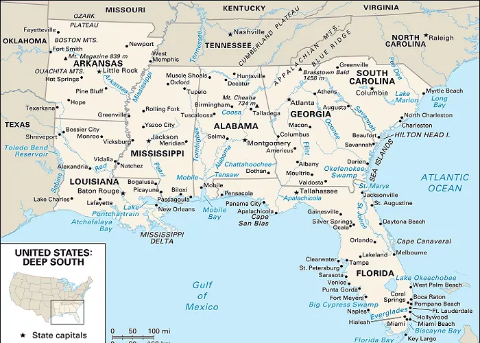
Florida, often referred to as the “Sunshine State,” is located in the southeastern region of the United States. Known for its extensive coastlines along both the Atlantic Ocean and the Gulf of Mexico, Florida’s unique geography has played a significant role in shaping its history, culture, and economy. Understanding the states that border Florida provides insight into its regional relationships and influences.
Florida is bordered by two U.S. states: Alabama and Georgia. To the south, it is separated from the Bahamas and Cuba by the Atlantic Ocean and the Straits of Florida, respectively. This positioning places Florida at a strategic crossroads between the continental United States, the Caribbean, and Latin America, influencing its cultural diversity and economic ties.
Georgia: The Northeastern Neighbor
Geographical Location
Georgia lies to the north of Florida, sharing a border that stretches approximately 200 miles. This boundary begins at the Atlantic Ocean and extends westward, following the path of the St. Mary’s River, which serves as a natural demarcation line between the two states. The border continues along the 31st parallel north, reaching the point where the Flint and Chattahoochee rivers converge to form the Apalachicola River.
Historical Context
The delineation of the Georgia-Florida border has its roots in colonial history. Initially defined by the Treaty of Paris in 1783, the boundary has undergone clarifications over the years, particularly concerning the western segment. Disputes over the exact location of the border led to the establishment of the 31st parallel as the definitive line, formalized by the Treaty of San Lorenzo in 1795.
Neighboring Regions
Beyond Florida, Georgia shares borders with Alabama to the west, South Carolina to the east, and Tennessee to the north. Its proximity to Florida has fostered various economic and cultural exchanges, especially in areas like agriculture, trade, and tourism.
Alabama: The Northwestern Neighbor
Geographical Location
Alabama borders Florida to the northwest, with their boundary defined by the 31st parallel north. This border begins at the confluence of the Chattahoochee and Flint rivers and extends westward to the Perdido River, which flows into the Gulf of Mexico.
Historical Context
The Alabama-Florida border has been a subject of historical interest due to early disputes over the exact location, particularly concerning the western section. These disputes were resolved through various agreements, including the Treaty of San Lorenzo in 1795, which established the 31st parallel as the boundary.
Neighboring Regions
Alabama is bordered by Mississippi to the west, Georgia to the east, and Tennessee to the north. Its proximity to Florida has led to shared interests in sectors such as agriculture, manufacturing, and transportation.
Coastal Boundaries and Maritime Influence
While Florida’s land borders are defined by Georgia and Alabama, its coastlines along the Atlantic Ocean and the Gulf of Mexico have significantly influenced its development. The Atlantic coast connects Florida to the Bahamas and the eastern Caribbean, while the Gulf coast links it to the western Caribbean and Mexico. This strategic location has made Florida a hub for international trade, tourism, and cultural exchange.
Key Highways Connecting Florida to Nearby States
| Highway | Connects Florida To | Major Cities Along Route |
|---|---|---|
| I-95 | Georgia, South Carolina | Jacksonville, Brunswick, Savannah |
| I-75 | Georgia, Tennessee | Tampa, Valdosta, Atlanta |
| I-10 | Alabama, Mississippi, Louisiana | Pensacola, Mobile, New Orleans |
| US-231 | Alabama, Georgia | Tallahassee, Dothan |
Why Are These Nearby States Important?
1. Tourism & Travel
- Georgia: Savannah’s historic charm attracts Florida road-trippers.
- Alabama: Gulf Shores beaches compete with Florida’s coast.
- Bahamas: A quick tropical getaway from Miami.
2. Business & Trade
- Port of Mobile (AL) works closely with Florida’s Gulf Coast ports.
- Atlanta (GA) is a major flight hub for Floridians.
3. Migration Trends
- Many retirees move between Florida and Georgia for tax benefits.
- Alabama’s lower cost of living draws some Floridians north.
Conclusion
Florida’s borders with Georgia and Alabama, along with its extensive coastlines, have played a pivotal role in shaping its identity as a diverse and dynamic state. These geographical relationships have fostered economic ties, cultural exchanges, and a unique blend of influences that continue to define Florida today.

